Our website is made possible by displaying online advertisements to our visitors.
Please consider supporting us by disabling your ad blocker.
Majadahonda
Majadahonda | |
|---|---|
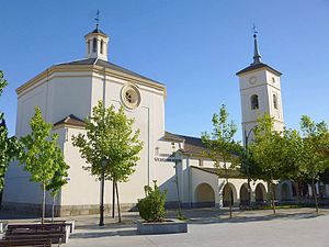
 Church of Santa Catalina Mártir | |
| Coordinates: 40°28′22″N 3°52′20″W / 40.47278°N 3.87222°W | |
| Country | Spain |
| Region | Community of Madrid |
| Comarca | Madrid metropolitan area |
| Government | |
| • Mayor | Lola Moreno (PP) |
| Area | |
• Total | 38.48 km2 (14.86 sq mi) |
| Elevation | 743 m (2,438 ft) |
| Population (2018)[1] | |
• Total | 71,785 |
| • Density | 1,900/km2 (4,800/sq mi) |
| Demonym | Majariegos |
| Time zone | UTC+1 (CET) |
| • Summer (DST) | UTC+2 (CEST) |
| Postal codes in Spain | 28220, 28221, 28222 |
| Area code | 34 (Spain) + 91 (Madrid) |
| Patron Saint | St. Catherine of Alexandria |
| Climate | Csa |
| Website | Official website |
Majadahonda (Spanish: [maxaðaˈonda] ⓘ) is a municipality in Spain, situated 16 km (9.9 mi) northwest of Madrid, in the Community of Madrid.
It lies alongside the motorway A6 Madrid-A Coruña.
The Puerta de Hierro university (public) hospital was relocated to Majadahonda from the western part of the city of Madrid into a newly built medical complex in 2009.
- ^ Municipal Register of Spain 2018. National Statistics Institute.
Previous Page Next Page


