Our website is made possible by displaying online advertisements to our visitors.
Please consider supporting us by disabling your ad blocker.
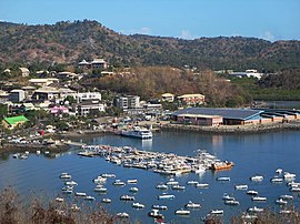
Mamoudzou
Mamoudzou | |
|---|---|
Prefecture and commune | |
 Mamoudzou | |
 Location of the commune (in red) within Mayotte | |
| Coordinates: 12°46′50″S 45°13′40″E / 12.7806°S 45.2278°E | |
| Country | France |
| Overseas region and department | Mayotte |
| Canton | 3 cantons |
| Intercommunality | CA Dembeni-Mamoudzou |
| Government | |
| • Mayor (2020–2026) | Ambdilwahedou Soumaila[1] |
Area 1 | 41.94 km2 (16.19 sq mi) |
| Population (2017)[2] | 71,437 |
| • Density | 1,700/km2 (4,400/sq mi) |
| Time zone | UTC+03:00 |
| INSEE/Postal code | 97611 /97600 |
| Elevation | 0–572 m (0–1,877 ft) |
| 1 French Land Register data, which excludes lakes, ponds, glaciers > 1 km2 (0.386 sq mi or 247 acres) and river estuaries. | |
Mamoudzou (French pronunciation: [mamudzu]; Momojou) is the capital city of Mayotte, a French overseas region and department in the Indian Ocean. Mamoudzou is the most populated commune (municipality) of Mayotte. It is located on Grande-Terre (or Maoré), the main island of Mayotte.
The commune is composed of six villages in addition to Mamoudzou. These are: Kawéni, Mtsapéré, Passamainti, Vahibé, Tsoundzou I and Tsoundzou II. The commune is also subdivided into three cantons: Mamoudzou-1, Mamoudzou-2 and Mamoudzou-3.
The government owns the radio station in Mamoudzou and broadcasts in French and Mahorian. The government departments are all situated in the town.
- ^ "Répertoire national des élus: les maires" (in French). data.gouv.fr, Plateforme ouverte des données publiques françaises. 13 September 2022.
- ^ Populations légales de Mayotte en 2017, INSEE
Previous Page Next Page


