Our website is made possible by displaying online advertisements to our visitors.
Please consider supporting us by disabling your ad blocker.
Manning River
| Manning River | |
|---|---|
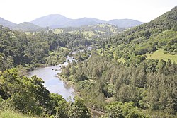
 Manning River, upstream of Mount George | |
 | |
| Etymology | In honour of Sir William Manning[2] |
| Native name | Boolumbahtee (Birrpayi)[1] |
| Location | |
| Country | Australia |
| State | New South Wales |
| Region | New England Tablelands, NSW North Coast (IBRA), Northern Tablelands, Mid North Coast |
| Local government area | Mid-Coast Council |
| Towns | Wingham, Taree |
| Physical characteristics | |
| Source | Mount Barrington, Great Dividing Range |
| • location | Barrington Tops National Park, near Ellerston |
| • coordinates | 31°54′S 151°28′E / 31.900°S 151.467°E |
| • elevation | 1,500 m (4,900 ft) |
| Mouth | Tasman Sea of the South Pacific Ocean |
• location | Old Bar and Harrington Point |
• coordinates | 31°53′S 152°42′E / 31.883°S 152.700°E |
• elevation | 0 m (0 ft) |
| Length | 261 km (162 mi) |
| Basin size | 8,125 km2 (3,137 sq mi) |
| Discharge | |
| • location | Near mouth |
| • average | 63 m3/s (2,000 GL/a)[3] |
| Basin features | |
| Tributaries | |
| • left | Backwater Creek, Pigna Barney River, Barnard River, Nowendoc River, Connollys Creek, Bobin Creek, Dingo Creek, Cedar Party Creek, Dawson River, Lansdowne River |
| • right | Gloucester River, Bakers Creek (New South Wales), Burrell Creek (New South Wales), Scotts Creek (New South Wales) |
| National parks | Barrington Tops, Woko, |
| [4] | |
Manning River (Biripi: Boolumbahtee[1]), an open and trained mature wave dominated barrier estuary,[5] is located in the Northern Tablelands and Mid North Coast districts of New South Wales, Australia. It is the only double delta river in the southern hemisphere in which there are two permanent entrances to the river, one at Old Bar and another at Harrington, and is famously one of only two rivers in the world to have permanent multiple entrances with the other being the Nile river in Egypt.[6]
- ^ a b Collier, Gloria; O'Hara, Joan (February 1998). "Oxley Island". The Journal (3). Manning Valley Historical Society. Archived from the original on 4 March 2016. Retrieved 16 March 2013.
- ^ Reed A. W. (1984). Place Names of Australia (3rd reprint ed.). Reed Books. p. 146. ISBN 0-589-50128-3.
- ^ "East Coastal Watersheds".
- ^ "Map of Manning River, NSW". Bonzle Digital Atlas of Australia. Retrieved 16 March 2013.
- ^ Roy, P. S.; Williams, R. J.; Jones, A. R.; Yassini, I.; et al. (2001). "Structure and Function of South-east Australian Estuaries". Estuarine, Coastal and Shelf Science. 53 (3): 351–384. doi:10.1006/ecss.2001.0796.
- ^ Driscoll, Julia (12 December 2019). "The river runs dry: Manning River at zero flow". The Canberra Times. Retrieved 1 October 2021.
Previous Page Next Page


