Our website is made possible by displaying online advertisements to our visitors.
Please consider supporting us by disabling your ad blocker.
Manzanares (river)
This article needs additional citations for verification. (December 2009) |
You can help expand this article with text translated from the corresponding article in Spanish. (December 2009) Click [show] for important translation instructions.
|
| Manzanares | |
|---|---|
 The Manzanares through El Pardo | |
 The Manzanares river | |
| Location | |
| Country | Spain |
| Region | Iberian Peninsula |
| Physical characteristics | |
| Source | Confluence of Arroyo de la Condesa and Arroyo de Valdemartín |
| • location | Manzanares el Real |
| • coordinates | 40°46′28″N 3°57′20″W / 40.77444°N 3.95556°W |
| • elevation | c. 1,810 m (5,940 ft) |
| Mouth | Jarama river |
• location | Rivas Vaciamadrid |
• coordinates | 40°18′13″N 3°32′23″W / 40.30361°N 3.53972°W |
• elevation | 533 m (1,749 ft) |
| Length | 92 km (57 mi) |
| Discharge | |
| • average | 10–15 m3/s (350–530 cu ft/s) |
| Basin features | |
| Progression | Jarama→ Tagus→ Atlantic Ocean |
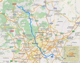
The Manzanares (Spanish pronunciation: [manθaˈnaɾes]) is a river in the centre of the Iberian Peninsula, which flows from the Sierra de Guadarrama, passes through Madrid, and eventually empties into the Jarama river, which in turn is a right-bank tributary to the Tagus.
In its urban section, the Manzanares River was modified to create a section of water several meters deep, in some parts navigable by canoes. This project of channeling and damming has been partially reversed in a re-naturalization project.
Previous Page Next Page


