Our website is made possible by displaying online advertisements to our visitors.
Please consider supporting us by disabling your ad blocker.
Mont-Saint-Pierre
Mont-Saint-Pierre | |
|---|---|
 | |
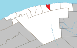
 Location within La Haute-Gaspésie RCM | |
| Coordinates: 49°13′21″N 65°48′26″W / 49.22250°N 65.80722°W[1] | |
| Country | Canada |
| Province | Quebec |
| Region | Gaspésie–Îles-de-la-Madeleine |
| RCM | La Haute-Gaspésie |
| Settled | 1858 |
| Constituted | January 1, 1947 |
| Government | |
| • Mayor | Magella Emond |
| • Federal riding | Haute-Gaspésie—La Mitis—Matane—Matapédia |
| • Prov. riding | Gaspé |
| Area | |
• Total | 51.78 km2 (19.99 sq mi) |
| • Land | 52.07 km2 (20.10 sq mi) |
| There is an apparent contradiction between two authoritative sources. | |
| Population | |
• Total | 186 |
| • Density | 3.6/km2 (9/sq mi) |
| • Pop (2016-21) | |
| • Dwellings | 133 |
| Time zone | UTC−5 (EST) |
| • Summer (DST) | UTC−4 (EDT) |
| Postal code(s) | |
| Area code(s) | 418 and 581 |
| Highways | |
| Website | www |
Mont-Saint-Pierre (French pronunciation: [mɔ̃ sɛ̃ pjɛʁ]) is a village municipality in Quebec, Canada, located in the regional county municipality of La Haute-Gaspésie in the administrative region of Gaspésie–Îles-de-la-Madeleine.
The village is located at the foot of the eponymous Mount Saint-Pierre. This 411 metres (1,348 ft) high mount juts into the Gulf of Saint Lawrence, separating Cove Mont-Louis from Cove Mont-Saint-Pierre, into which the Mont-Saint-Pierre River flows. The place was formerly called Rivière-à-Pierre.[1]
The 2021 census there were 186 inhabitants.
Mont-Saint-Pierre is well known for hang-gliding and paragliding, and home to the Mont-Saint-Pierre Ecological Reserve. The Festival of Free Flight (Fête de Vol Libre) is held each year since 1978.
Previous Page Next Page


