Our website is made possible by displaying online advertisements to our visitors.
Please consider supporting us by disabling your ad blocker.
Narsingdi
Narsingdi
নরসিংদী | |
|---|---|
City and Municipality | |
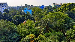
 drone view city of Narsingdi | |
| Coordinates: 23°55′23″N 90°42′44″E / 23.92306°N 90.71222°E | |
| Country | |
| Division | Dhaka |
| District | Narsingdi |
| Upazila | Narsingdi Sadar |
| Government | |
| • Type | Mayor–Council |
| • Body | Narsingdi Municipal Corporation |
| Area | |
• Total | 14.8 km2 (5.7 sq mi) |
| Population | |
• Total | 180,699 |
| • Density | 12,000/km2 (32,000/sq mi) |
| Time zone | UTC+6 (Bangladesh Time) |
| Postal code | 1600 |
| National Dialing Code | +880 |
Narsingdi (Bengali: নরসিংদী) is a city and headquarters of Narsingdi District in the division of Dhaka, Bangladesh.[2] The Dhaka–Sylhet highway connects Narsingdi with the capital and other major cities. The district is located between 24.1344° N and 90.7860° E. It is surrounded by Tarowa on the north, Hazipur on the east, the Meghna River on the south, and by Chouwala and Kamargaon on the west.[3] Narsingdi is one of the most important cities for the garment industry. The city is famous for its textile craft industry.
- ^ Population and Housing Census 2022 National Report (PDF). Vol. 1. Bangladesh Bureau of Statistics. November 2023.
- ^ "Narsingdi city's area and population". Retrieved 2019-08-31.
- ^ "District at a glance". Narsingdi District. Retrieved 2022-09-23.
Previous Page Next Page


