Our website is made possible by displaying online advertisements to our visitors.
Please consider supporting us by disabling your ad blocker.
Paavola
Paavola | |
|---|---|
Former municipality | |
| Paavolan kunta Paavola kommun | |
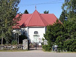
 Paavola Church | |
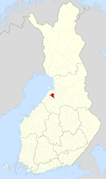
 Location of Paavola in Finland | |
| Coordinates: 64°36′30″N 025°12′20″E / 64.60833°N 25.20556°E | |
| Country | Finland |
| Region | Northern Ostrobothnia |
| Established | 1874 |
| Consolidated | 1973 |
| Area | |
| • Land | 565.8 km2 (218.5 sq mi) |
| Population (1970)[1] | |
• Total | 4,568 |
| Time zone | UTC+2 (EET) |
| • Summer (DST) | UTC+3 (EEST) |
Paavola is a former municipality of Finland, now a village in the municipality of Siikajoki. The village is located beside the Siikajoki river. Though lacking rail transport connections, the settlement does lie beside the crossroads of routes 86 and 807.
In 1973, Paavola was consolidated with the neighboring municipality of Revonlahti to form the municipality of Ruukki. Ruukki in turn was consolidated with Siikajoki in 2007.
- ^ a b "Suomen kunnat: Paavola" (in Finnish). Retrieved 1 April 2010.
Previous Page Next Page


