Our website is made possible by displaying online advertisements to our visitors.
Please consider supporting us by disabling your ad blocker.
Pampa micropolitan area
Pampa micropolitan area | |
|---|---|
| Pampa, TX μSA | |
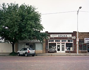
 Pampa business district | |
 | |
| Coordinates: 35°37′11″N 100°48′47″W / 35.6197°N 100.8131°W | |
| Country | |
| State | |
| Largest city | Pampa |
| Time zone | UTC-6 (CST) |
| • Summer (DST) | UTC-5 (CDT) |
The Pampa micropolitan [statistical] area is a micropolitan area in the Texas Panhandle that covers two counties – Gray and Roberts. As of the 2000 census, the region had a population of 23,631 (though a July 1, 2009, estimate placed the population at 22,952).[1]
- ^ "Table 1. Annual Estimates of the Population of Metropolitan and Micropolitan Statistical Areas: April 1, 2000 to July 1, 2009 (CBSA-EST2009-01)". 2009 Population Estimates. United States Census Bureau, Population Division. 23 March 2010. Archived from the original (CSV) on 15 June 2010. Retrieved 26 March 2010.
Previous Page Next Page


