Our website is made possible by displaying online advertisements to our visitors.
Please consider supporting us by disabling your ad blocker.
Ponta do Sol, Madeira
Ponta do Sol | |
|---|---|
 The seafront of Ponta do Sol | |
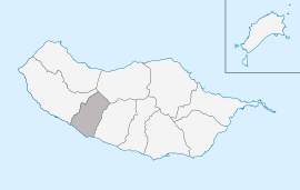
 Location in Madeira | |
| Coordinates: 32°40′50″N 17°6′15″W / 32.68056°N 17.10417°W | |
| Country | |
| Auton. region | Madeira |
| Island | Madeira |
| Established | Settlement: c. 1420 Municipality: 2 December 1501 |
| Parishes | 3 |
| Government | |
| • President | Celia Marques Luís |
| Area | |
• Total | 46.19 km2 (17.83 sq mi) |
| Elevation | 34 m (112 ft) |
| Population (2011) | |
• Total | 8,862 |
| • Density | 190/km2 (500/sq mi) |
| Time zone | UTC+00:00 (WET) |
| • Summer (DST) | UTC+01:00 (WEST) |
| Postal code | 9360-219 |
| Area code | 291 |
| Website | pontadosol.pt |
Ponta do Sol (Portuguese pronunciation: [ˈpõtɐ ðu ˈsɔl] ⓘ; English: "Cape of the Sun") is a municipality in the southwestern coast of the island of Madeira, in the archipelago of Madeira. The population in 2011 was 8,862,[1] in an area of 46.19 km2 (17.83 sq mi).[2]
Previous Page Next Page


