Our website is made possible by displaying online advertisements to our visitors.
Please consider supporting us by disabling your ad blocker.
Rifle, Colorado
Rifle, Colorado | |
|---|---|
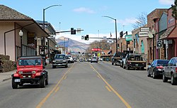
 Railroad Avenue in Rifle looking north. | |
 Location in Garfield County and Colorado | |
| Coordinates: 39°32′05″N 107°46′22″W / 39.53472°N 107.77278°W[3] | |
| Country | |
| State | |
| County | Garfield County[2] |
| City | Rifle[1] |
| Founded | 1882[4] |
| Incorporated | August 18, 1905[5] |
| Founded by | Abram Maxfield |
| Named for | Rifle Creek |
| Government | |
| • Type | Home-rule municipality[1] |
| • Mayor | Sean Strode |
| Area | |
• Total | 7.15 sq mi (18.53 km2) |
| • Land | 7.03 sq mi (18.22 km2) |
| • Water | 0.12 sq mi (0.31 km2) |
| Elevation | 5,519 ft (1,682 m) |
| Population | |
• Total | 10,437 |
| • Density | 1,379.87/sq mi (532.75/km2) |
| Time zone | UTC-7 (Mountain (MST)) |
| • Summer (DST) | UTC-6 (MDT) |
| ZIP code[8] | 81650 |
| Area code | 970 |
| FIPS code | 08-64255 |
| GNIS feature ID | 2410947[3] |
| Website | www |
Rifle is a home-rule municipality in, and the most populous community of, Garfield County, Colorado, United States. Its population was 10,437 at the 2020 census.[7] Rifle is a regional center of the cattle-ranching industry located along Interstate 70 and the Colorado River just east of the Roan Plateau, which dominates the western skyline of the town. The town was founded in 1882[4] by Abram Maxfield, and was incorporated in 1905 along Rifle Creek, near its mouth on the Colorado. The community takes its name from the creek.[9]
- ^ a b c "Active Colorado Municipalities". State of Colorado, Colorado Department of Local Affairs, Division of Local Government. Retrieved January 27, 2021.
- ^ "Colorado Counties". State of Colorado, Colorado Department of Local Affairs, Division of Local Government. Retrieved January 27, 2021.
- ^ a b c U.S. Geological Survey Geographic Names Information System: Rifle, Colorado
- ^ a b City of Rifle website
- ^ "Colorado Municipal Incorporations". State of Colorado, Department of Personnel & Administration, Colorado State Archives. December 1, 2004. Retrieved September 2, 2007.
- ^ "2019 U.S. Gazetteer Files". United States Census Bureau. Retrieved July 1, 2020.
- ^ a b "QuickFacts: Colorado, United States". United States Census Bureau. Retrieved September 5, 2021.
- ^ "ZIP Code Lookup". United States Postal Service. Archived from the original (JavaScript/HTML) on September 27, 2004. Retrieved December 24, 2007.
- ^ Rifle Shots: The Story of Rifle, Colorado, compiled by the Reading Club of Rifle, Colorado, 1973.
Previous Page Next Page


