Our website is made possible by displaying online advertisements to our visitors.
Please consider supporting us by disabling your ad blocker.
River Brent
This article needs additional citations for verification. (July 2015) |
| Brent | |
|---|---|
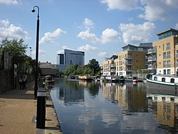
 River Brent at Brentford | |
 | |
| Location | |
| Country | England |
| Counties | Greater London |
| Districts / Boroughs | London Borough of Barnet, London Borough of Brent, London Borough of Ealing, London Borough of Hounslow |
| Towns | Hendon, Neasden, Perivale, Greenford, Hanwell |
| Physical characteristics | |
| Source | |
| • location | London Borough of Barnet, Greater London |
| Mouth | River Thames |
• location | Brentford, Greater London |
| Length | 29 km (18 mi) |
| Discharge | |
| • location | Costons Lane, Greenford |
| • average | 1.32 m3/s (47 cu ft/s) |
| • minimum | 0.19 m3/s (6.7 cu ft/s)3 August 1995 |
| • maximum | 42.9 m3/s (1,510 cu ft/s)12 October 1993 |
| Discharge | |
| • location | Monks Park |
| • average | 1.00 m3/s (35 cu ft/s) |
| Discharge | |
| • location | Brent Cross |
| • average | 0.34 m3/s (12 cu ft/s) |
| Basin features | |
| Tributaries | |
| • left | Dollis Brook, Decoy Brook, Clitterhouse Brook, Silk Stream, Wealdstone Brook, Gadder brook |
| • right | Mutton Brook, Peggy Back's (subterranean) drain |
The River Brent is a river in west and northwest London, England, and a tributary of the River Thames. 17.9 miles (28.8 km) in length, it rises in the Borough of Barnet and flows in a generally south-west direction before joining the Tideway stretch of the Thames at Brentford.[1]
- ^ Baxter, Alan (January 2011). "11. Brent River Valley". London's Natural Signatures: The London Landscape Framework (PDF). pp. 74–77. Archived from the original (PDF) on 4 September 2012. Retrieved 29 September 2021.
Previous Page Next Page


