Our website is made possible by displaying online advertisements to our visitors.
Please consider supporting us by disabling your ad blocker.
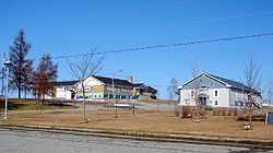
Roquemaure, Quebec
You can help expand this article with text translated from the corresponding article in French. (May 2023) Click [show] for important translation instructions.
|
Roquemaure | |
|---|---|
 | |
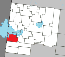
 Location within Abitibi-Ouest RCM | |
| Coordinates: 48°36′N 79°24′W / 48.600°N 79.400°W[1] | |
| Country | Canada |
| Province | Quebec |
| Region | Abitibi-Témiscamingue |
| RCM | Abitibi-Ouest |
| Settled | 1933 |
| Constituted | January 1, 1952 |
| Government | |
| • Mayor | Mathieu Guillemette |
| • Federal riding | Abitibi—Témiscamingue |
| • Prov. riding | Abitibi-Ouest |
| Area | |
• Total | 153.97 km2 (59.45 sq mi) |
| • Land | 120.02 km2 (46.34 sq mi) |
| Population (2021)[3] | |
• Total | 409 |
| • Density | 3.4/km2 (9/sq mi) |
| • Pop (2016-21) | |
| • Dwellings | 215 |
| Time zone | UTC−5 (EST) |
| • Summer (DST) | UTC−4 (EDT) |
| Postal code(s) | |
| Area code | 819 |
| Highways | No major routes |
| Website | roquemaure |
Roquemaure (French pronunciation: [ʁɔkmɔʁ]) is a municipality in northwestern Quebec, Canada in the MRC d'Abitibi-Ouest. It covers 120.02 km2 and had a population of 409 as of the 2021 Canadian census.
The municipality was incorporated on January 1, 1952. The name evokes the memory of Jean-Georges Dejean de Roquemaure, who was promoted to second lieutenant in 1723, captain in 1735, lieutenant-colonel in the Queen's regiment in 1755 and brigadier in 1759. Roquemaure is originally a place name from the south of France, derived from the Occitan ròca maura, francised as roque maure and meaning ‘rock’, ‘dark rock’ or ‘black’.[1]
- ^ a b Cite error: The named reference
toponymiewas invoked but never defined (see the help page). - ^ a b "Roquemaure". Répertoire des municipalités (in French). Ministère des Affaires municipales et de l'Habitation. Retrieved 2023-07-11.
- ^ a b "Roquemaure census profile". 2021 Census data. Statistics Canada. Retrieved 2022-04-29.
Previous Page Next Page


