Our website is made possible by displaying online advertisements to our visitors.
Please consider supporting us by disabling your ad blocker.
Schneeberg (Fichtel Mountains)
| Schneeberg | |
|---|---|
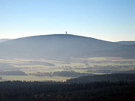
 The Schneeberg in October 2006 | |
| Highest point | |
| Elevation | 1,051 m (3,448 ft) |
| Coordinates | 50°03′N 11°51′E / 50.05°N 11.85°E |
| Geography | |
 | |
| Location | Bavaria, Germany |
| Parent range | Fichtel Mountains |

Schneeberg (1,051 m above sea level (NN)) is the highest mountain in the Fichtel Mountains, a mountain range in Upper Franconia in northeast Bavaria, Germany. It can be readily identified from a distance by its squat tower - a relic of the Cold War. The summit comprises a jumble of granite rocks and a rock pillar (Felsburg) on which the Backöfele observation tower stands and is still dominated by the relics of military installations including its Cold War listening post.
From a natural region perspective, the mountain is part of the major unit of the High Fichtel Mountains (Hohes Fichtelgebirge, 394).[1][2] It is the highest point in the Bavarian province of Upper Franconia.
- ^ E. Meynen und J. Schmithüsen: Handbuch der naturräumlichen Gliederung Deutschlands – Bundesanstalt für Landeskunde, Remagen/Bad Godesberg 1953–1962 (9 issues in 8 books, updated map 1:1,000,000 scale with major units 1960)
- ^ Map services of the Federal Agency for Nature Conservation
Previous Page Next Page


