Our website is made possible by displaying online advertisements to our visitors.
Please consider supporting us by disabling your ad blocker.
St. Johns Bridge
St. Johns Bridge | |
|---|---|
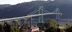
 St. Johns Bridge in Portland, Oregon, in 2005 | |
| Coordinates | 45°35′06″N 122°45′53″W / 45.58508°N 122.76477°W |
| Carries | 4 lanes of |
| Crosses | Willamette River |
| Locale | Portland, Oregon (Cathedral Park neighborhood, Northwest Industrial District/Linnton) |
| Maintained by | Oregon Department of Transportation |
| Heritage status | Portland Historic Landmark[1] |
| Characteristics | |
| Design | Suspension bridge, Gothic |
| Total length | 2,067 feet (630 m) |
| Height | 400 feet (120 m) |
| Longest span | 1,207 feet (368 m) |
| Clearance below | 205 feet (62 m) |
| History | |
| Designer | David B. Steinman |
| Opened | June 13, 1931 |
| Location | |
 | |
The St. Johns Bridge is a steel suspension bridge that spans the Willamette River in Portland, Oregon, United States, between the Cathedral Park neighborhood in North Portland and the Linnton and Northwest Industrial neighborhoods in Northwest Portland. It carries the U.S. Route 30 Bypass. It is the only suspension bridge in the Willamette Valley and one of three public highway suspension bridges in Oregon.[2]
The bridge has a 1,207-foot (368 m) center span and a total length of 2,067 feet (630 m).[3] It is the tallest bridge in Portland, with two 400-foot-tall (120 m) towers and a 205-foot (62 m) navigational clearance.[4] The adjacent park and neighborhood of Cathedral Park are named after the Gothic arch design of the bridge's towers and supports.
- ^ "Historic Landmarks -- Portland, Oregon" (XLS). Portland Historic Landmarks Commission. July 2010. Retrieved May 8, 2016.
- ^ "St. Johns Bridge Rehabilitation Project". Oregon Department of Transportation. Archived from the original on December 20, 2006. Retrieved November 5, 2006.
- ^ "St. Johns Bridge Dedication". Center for Columbia River History. Archived from the original on May 9, 2016. Retrieved November 5, 2006.
- ^ Dwight A. Smith; James B. Norman; Pieter T. Dykman (1989). Historic Highway Bridges of Oregon. Oregon Historical Society Press. p. 113. ISBN 0-87595-205-4.
Previous Page Next Page


