Our website is made possible by displaying online advertisements to our visitors.
Please consider supporting us by disabling your ad blocker.
Sullivan, Missouri
Sullivan, Missouri | |
|---|---|
| City of Sullivan | |
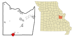
 Location of Sullivan, Missouri | |
| Coordinates: 38°12′46″N 91°09′49″W / 38.21278°N 91.16361°W | |
| Country | United States |
| State | Missouri |
| Counties | Franklin, Crawford |
| Founded | 1856 |
| Incorporated | 1883 |
| Named for | Stephen Sullivan |
| Government | |
| • Mayor | Dennis Watz |
| • City Clerk | Jan Koch |
| • City Administrator | J.T. Hardy |
| Area | |
• Total | 8.19 sq mi (21.21 km2) |
| • Land | 8.19 sq mi (21.21 km2) |
| • Water | 0.00 sq mi (0.00 km2) |
| Elevation | 974 ft (297 m) |
| Population (2020) | |
• Total | 6,906 |
| • Density | 843.22/sq mi (325.59/km2) |
| Time zone | UTC-6 (Central (CST)) |
| • Summer (DST) | UTC-5 (CDT) |
| ZIP Code | 63080 |
| Area code | 573 |
| FIPS code | 29-71440[6] |
| GNIS feature ID | 2395998[5] |
| Website | www |
Sullivan is a city that straddles the border of Franklin and Crawford counties in the U.S. state of Missouri. The population was 6,906 at the 2020 census.
- ^ "Welcome to City of Sullivan, MO - City_council".
- ^ "Welcome to City of Sullivan, MO - City_clerk".
- ^ "Welcome to City of Sullivan, MO - Administration".
- ^ "ArcGIS REST Services Directory". United States Census Bureau. Retrieved August 28, 2022.
- ^ a b U.S. Geological Survey Geographic Names Information System: Sullivan, Missouri
- ^ "U.S. Census website". United States Census Bureau. Retrieved January 31, 2008.
Previous Page Next Page


