Our website is made possible by displaying online advertisements to our visitors.
Please consider supporting us by disabling your ad blocker.
Swat River
| Swat River سوات | |
|---|---|
 | |
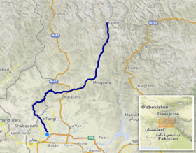
 Course of the Swat (interactive map) | |
| Location | |
| Country | |
| Province | |
| District | Swat |
| Physical characteristics | |
| Source | Hindu Kush Mountains |
| Source confluence | Usho and Gabral rivers |
| • location | Kalam |
| Mouth | Kabul River |
• location | Charsadda |
| Length | 240 km (150 mi) |
| Basin size | 13,000 km2 (5,000 sq mi) |
| Discharge | |
| • location | Munda |
| • average | 280 cubic m/s |
| Basin features | |
| Tributaries | |
| • left | Ushu Khwar, Bashigram Khwar |
| • right | Daral Khwar, Gabral Khwar |
The Swat River (Urdu: دریائے سوات, Pashto: سوات سیند) is a perennial river in the northern region of the Khyber-Pakhtunkhwa Province of Pakistan. The river's source is in the high glacial valleys of the Hindu Kush mountains, where it then flows into the Kalam Valley before forming the spine of the wider Swat Valley.
Previous Page Next Page


