Our website is made possible by displaying online advertisements to our visitors.
Please consider supporting us by disabling your ad blocker.
Tenri, Nara
Tenri
天理市 | |
|---|---|
 Top left: View of Headquarter in Tenri religious community, Top right: Tenri religious school, Middle left: View of a point of side of mount Miwa road, Middle right: Stone site in Ryuo Mount Castle, Bottom: Tenri Reference Museum | |
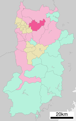
 Location of Tenri in Nara Prefecture | |
 | |
| Coordinates: 34°35′48″N 135°50′14″E / 34.59667°N 135.83722°E | |
| Country | Japan |
| Region | Kansai |
| Prefecture | Nara |
| Government | |
| • Mayor | Keisaku Minami |
| Area | |
• Total | 86.42 km2 (33.37 sq mi) |
| Population (September 30, 2024) | |
• Total | 60,890 |
| • Density | 700/km2 (1,800/sq mi) |
| Time zone | UTC+09:00 (JST) |
| City hall address | 605 Kawaharajō-chō, Tenri-shi, Nara-ken |
| Website | Official website |
| Symbols | |
| Flower | Ume |
| Tree | Ginkgo |

Tenri (天理市, Tenri-shi) is a city located in Nara Prefecture, Japan. As of 30 September 2024[update], the city had an estimated population of 60,890 in 29456 households, and a population density of 700 persons per km2.[1] The total area of the city is 86.42 km2 (33.37 sq mi).[2] The city is named after the Japanese new religion Tenrikyo, which has its headquarters in the city.
- ^ "Tenri City official statistics" (in Japanese). Japan.
- ^ "第1章 天理市の概要" (PDF) (in Japanese). Japan: Tenri City. Retrieved 23 October 2024.
Previous Page Next Page


