Our website is made possible by displaying online advertisements to our visitors.
Please consider supporting us by disabling your ad blocker.
Thundorf, Switzerland
Thundorf | |
|---|---|
 | |
| Coordinates: 47°33′N 8°58′E / 47.550°N 8.967°E | |
| Country | Switzerland |
| Canton | Thurgau |
| District | Frauenfeld |
| Government | |
| • Mayor | Stefan Blatter |
| Area | |
• Total | 15.6 km2 (6.0 sq mi) |
| Elevation | 546 m (1,791 ft) |
| Population (31 December 2018)[2] | |
• Total | 1,437 |
| • Density | 92/km2 (240/sq mi) |
| Time zone | UTC+01:00 (Central European Time) |
| • Summer (DST) | UTC+02:00 (Central European Summer Time) |
| Postal code(s) | 8512 |
| SFOS number | 4611 |
| ISO 3166 code | CH-TG |
| Localities | Thundorf, Kirchberg, Lustdorf, Wetzikon |
| Surrounded by | Affeltrangen, Amlikon-Bissegg, Felben-Wellhausen, Frauenfeld, Hüttlingen, Lommis, Matzingen, Stettfurt |
| Website | www SFSO statistics |
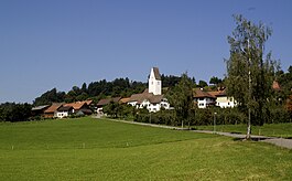
Thundorf (pronounced [ˈtuːndɔrf], in the local dialect [ˈtuəndɔrfː] or [ˈtuəndərəfː])[3] is a municipality in the district of Frauenfeld in the canton of Thurgau in Switzerland.
The village of Thundorf lies on a plateau above Frauenfeld. In 1995, the communal territory was enlarged to the east, when Wetzikon and Lustdorf, the latter of which until then was autonomous, were joined to it.
- ^ a b "Arealstatistik Standard - Gemeinden nach 4 Hauptbereichen". Federal Statistical Office. Retrieved 13 January 2019.
- ^ "Ständige Wohnbevölkerung nach Staatsangehörigkeitskategorie Geschlecht und Gemeinde; Provisorische Jahresergebnisse; 2018". Federal Statistical Office. 9 April 2019. Retrieved 11 April 2019.
- ^ Philipp Obrist/Andres Kristol, Thundorf TG (Frauenfeld) in: Dictionnaire toponymique des communes suisses – Lexikon der schweizerischen Gemeindenamen – Dizionario toponomastico dei comuni svizzeri (DTS|LSG), Centre de dialectologie, Université de Neuchâtel, Verlag Huber, Frauenfeld/Stuttgart/Wien 2005, ISBN 3-7193-1308-5 and Éditions Payot, Lausanne 2005, ISBN 2-601-03336-3, p. 873f.
Previous Page Next Page


