Our website is made possible by displaying online advertisements to our visitors.
Please consider supporting us by disabling your ad blocker.
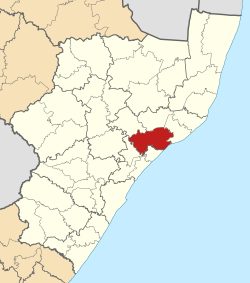
UMlalazi Local Municipality
uMlalazi | |
|---|---|
 Location in KwaZulu-Natal | |
| Country | South Africa |
| Province | KwaZulu-Natal |
| District | King Cetshwayo |
| Seat | Eshowe |
| Wards | 26 |
| Government | |
| • Type | Municipal council |
| • Mayor | Councillor T B Zulu |
| Area | |
• Total | 2,214 km2 (855 sq mi) |
| Population (2016)[2] | |
• Total | 223,140 |
| • Density | 100/km2 (260/sq mi) |
| Racial makeup (2011) | |
| • Black African | 97.1% |
| • Coloured | 0.6% |
| • Indian/Asian | 0.7% |
| • White | 1.5% |
| First languages (2011) | |
| • Zulu | 92.1% |
| • English | 3.5% |
| • Southern Ndebele | 1.3% |
| • Other | 3.1% |
| Time zone | UTC+2 (SAST) |
| Municipal code | KZN284 |
uMlalazi Local Municipality is an administrative area in the King Cetshwayo District of KwaZulu-Natal in South Africa. The municipality is named after the uMlalazi River.[4]
- ^ "Contact list: Executive Mayors". Government Communication & Information System. Archived from the original on 14 July 2010. Retrieved 22 February 2012.
- ^ a b "Statistics by place" (PDF). Statistics South Africa. Retrieved 9 June 2020.
- ^ "Statistics by place". Statistics South Africa. Retrieved 27 September 2015.
- ^ South African Languages - Place names
Previous Page Next Page


