Our website is made possible by displaying online advertisements to our visitors.
Please consider supporting us by disabling your ad blocker.
Wola
Wola | |
|---|---|
 Rondo Daszyńskiego | |
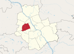
 Location of Wola within Warsaw | |
 Neighbourhoods of Wola | |
| Country | |
| Voivodeship | Masovian |
| County/City | Warsaw |
| Government | |
| • Mayor | Krzysztof Strzałkowski |
| Area | |
• Total | 19.26 km2 (7.44 sq mi) |
| Population (2019) | |
• Total | 140,958[1] |
| Time zone | UTC+1 (CET) |
| • Summer (DST) | UTC+2 (CEST) |
| Area code | +48 22 |
| Car plates | WY |
| Website | wola |
Wola (Polish pronunciation: [ˈvɔla] ⓘ) is a district in western Warsaw, Poland. An industrial area with traditions reaching back to the early 19th century, it underwent a transformation into a major financial district, featuring various landmarks and some of the tallest office buildings in the city.
- ^ "Powierzchnia i ludność w przekroju terytorialnym w 2019 roku. Tabl. 21 Powierzchnia, ludność oraz lokaty według gmi". stat.gov.pl. Główny Urząd Statystyczny. Archived from the original on 25 July 2019. Retrieved 2 September 2020.
Previous Page Next Page


