Our website is made possible by displaying online advertisements to our visitors.
Please consider supporting us by disabling your ad blocker.
Ziebach County, South Dakota
Ziebach County | |
|---|---|
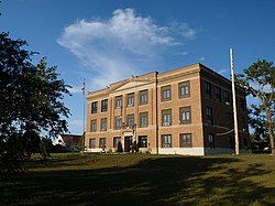
 Ziebach County Courthouse | |
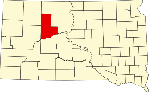
 Location within the U.S. state of South Dakota | |
 South Dakota's location within the U.S. | |
| Coordinates: 44°59′N 101°40′W / 44.98°N 101.67°W | |
| Country | |
| State | |
| Founded | 1911 |
| Named for | Frank M. Ziebach |
| Seat | Dupree |
| Largest city | Dupree |
| Area | |
• Total | 1,971 sq mi (5,100 km2) |
| • Land | 1,961 sq mi (5,080 km2) |
| • Water | 9.3 sq mi (24 km2) 0.5% |
| Population (2020) | |
• Total | 2,413 |
• Estimate (2023) | 2,322 |
| • Density | 1.2/sq mi (0.47/km2) |
| Time zone | UTC−7 (Mountain) |
| • Summer (DST) | UTC−6 (MDT) |
| Congressional district | At-large |
Ziebach County is a county in the U.S. state of South Dakota. As of the 2020 census, the population was 2,413.[1] Its county seat is Dupree.[2] It is the last county (or county equivalent) in the United States alphabetically.
Ziebach County consists entirely of indian reservations. Most of the county is within the Cheyenne River Indian Reservation and the remainder is within the Standing Rock Indian Reservation. The county's per-capita income makes it the fourth-poorest county in the United States.[3]
- ^ "State & County QuickFacts". United States Census Bureau. Retrieved March 20, 2024.
- ^ "Find a County". National Association of Counties. Archived from the original on May 31, 2011. Retrieved June 7, 2011.
- ^ Merchant, N. (February 13, 2011). "A look inside America's poorest county". Associated Press. Retrieved April 4, 2012.
Previous Page Next Page


