Back Honolulu AF ሆኖሉሉ AM Honolulu AN Hānolūlu ANG هونولولو Arabic هونولولو ARZ Honolulu AST Honolulu (Havay) AZ هونولولو AZB Honolulu BAN
| Honolulu | |
|---|---|
| Spitznam: Crossroads of the Pacific, Sheltered Bay | |
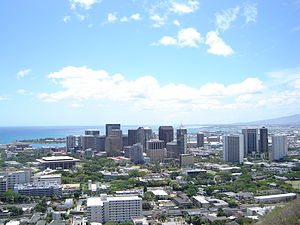
 Blick aufs Stodzentrum vo Honolulu vom Pūowaina (Punchbowl Crater) aus | |
| Log af Hawaii | |
| Basisdaten | |
| Stoot: | Vereinigte Staaten |
| Bundesstaat: | Hawaii |
| County: | Honolulu County |
| Koordinaten: | 21° 19′ N, 157° 50′ W |
| Zeidzone: | UTC−10 |
| Einwohna: – Metropolregion: |
337.256 (Stand: 2010) 953.207 |
| Bevökarungsdichtn: | 1.519,2 Einwohna pro km2 |
| Flechn: | 272,1 km2 (ca. 68 mi2) davo 222 km2 (ca. 86 mi2) Land |
| Höhe: | 6 m |
| Postleitzoin: | 96801–96850 |
| Vorwoi: | +1 808 |
| FIPS: | 15-17000 |
| GNIS-ID: | 0366212 |
| Netzseitn: | www.co.honolulu.hi.us |
| Buagamoasta: | Rick Blangiardi[1] |
 Blick auf Honolulu, beim Obflug vom International Airport | |
Honolulu is de Haptstod vom US-Bundesstoot Hawaii und liegt im Sidn vo da Insl Oʻahu. Sie is oane vo de gresstn Städt vom Pazifik und s Luftdrehkreiz vo nam Gebiet. Honolulu is a beliabts Touristnzui, bsondas da Stodtei Waikīkī.
Auf Boarisch hoasst Honolulu „gschitzta Hafn“.
- ↑ www.honolulu.gov. (abgerufen am 23. Mäerz 2022).
