Back Kiritimati AF Kiritimati ALS كيريتيماتي Arabic كيريتيماس ARZ Кірыцімаці BE Рождество (остров, Кирибати) Bulgarian किरितिमाती BH Kiritimati BR Kiritimati Catalan Рождествон гӀайре (Кирибати) CE
| Kiritimati | ||
|---|---|---|
 | ||
| Gewässer | Pazifischer Ozean | |
| Archipel | Line Islands | |
| Geographische Lage | 1° 54′ N, 157° 24′ W | |
|
| ||
| Pflichtparameter INSELN fehlt | ||
| Hauptinsel | Kiritimati | |
| Länge | 43,9 km | |
| Breite | 39,6 km | |
| Landfläche | 388,39 km² | |
| Lagunenfläche | 345,54 km² | |
| Höchste Erhebung | Joe’s Hill 13 m | |
| Einwohner | 7369 (2020[1]) | |
 | ||
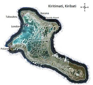
Kiritimati (kiribatische Aussprache: [], kiribatische Schreibung des Wortlauts „Christmas“; vormals Christmas Island, „Weihnachtsinsel“) ist ein zu Kiribati gehörendes Atoll der Line Islands im Zentralpazifik.
- ↑ Aritita Tekaieti (Hrsg.): 2020 Population and Housing General Report and Results. Republic of Kiribati – National Statistics Office, Ministry of Finance, Juli 2021, Table G-2: Total population of Kiribati by division, island and sex: 2020 PHC Kiribati, S. 18 (englisch, Downloadlink [PDF; 48,2 MB; abgerufen am 2. März 2023]).
