Back جزيرة سالاواتي Arabic Salawati AST Salavati AZ Nusa Salawati BAN Salawati Catalan Pulau Salawati CEB Salawati English Salavati EO Salawati Spanish Salawati Finnish
| Salawati
| ||
|---|---|---|
 | ||
| Gewässer | Halmaherasee, Pazifischer Ozean | |
| Inselgruppe | Raja Ampat | |
| Geographische Lage | 1° 6′ S, 130° 52′ O | |
|
| ||
| Fläche | 1 623 km² | |
| Höchste Erhebung | Gunung Wagom 700 m | |
| Hauptort | Samate | |
 | ||
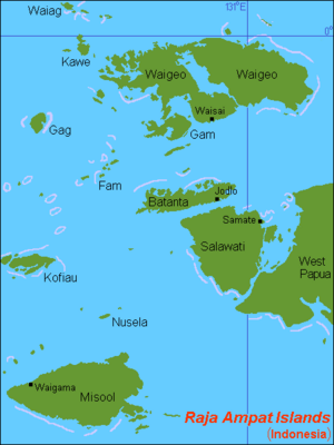
Salawati ist mit einer Fläche von 1623 km² eine der vier Hauptinseln des Archipels von Raja Ampat vor der Küste Westneuguineas (Indonesien).
