Back نهر أخيلوس Arabic نهر اخيلوس ARZ Ахелой (Гърция) Bulgarian Riu Aqueloos Catalan Achelóos Potamós CEB Achelóos (řeka) Czech Ахелоос CV Achelous (flod) Danish Acheloos (Fluss) German Αχελώος Greek
| Acheloos | |
|---|---|
 | |
 | |
| Location | |
| Country | Greece |
| Physical characteristics | |
| Source | |
| • location | Pindus mountains |
| • coordinates | 39°41′13″N 21°8′31″E / 39.68694°N 21.14194°E |
| Mouth | |
• location | Ionian Sea |
• coordinates | 38°19′53″N 21°6′5″E / 38.33139°N 21.10139°E |
| Length | 220 km (140 mi) |
| Basin size | 5,472 km2 (2,113 sq mi) |
| Discharge | |
| • average | 7,800,000,000 m3 (6,323,563 acre⋅ft) (annual mean) |


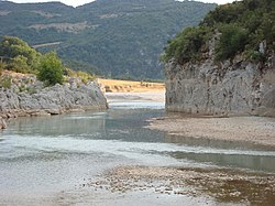
The Achelous (Greek: Αχελώος, Ancient Greek: Ἀχελῷος Akhelôios), also Acheloos, is a river in Epirus, western Greece. It is 220 km (137 mi) long.[1][2] It formed the boundary between Acarnania and Aetolia of antiquity. It empties into the Ionian Sea. In ancient times its spirit was venerated as the river god Achelous.
Herodotus, taking notice of the shoreline-transforming power of the Acheloos River, even compared it to the Nile in this respect:
- 'There are other rivers as well which, though not as large as the Nile, have had substantial results. In particular (although I could name others), there is the Achelous, which flows through Acarnania into the sea and has already turned half the Echinades islands into mainland.' (2.10, trans. Waterfield)
It is said to have been called more anciently Thoas, Axenus and Thestius.[3]
- ^ Greece in Figures January - March 2018, p. 12
- ^ "Preliminary Flood Risk Assessment" (in Greek). Ministry of Environment, Energy and Climate Change. p. 49. Archived from the original on 15 February 2020.
- ^ William Smith, ACHELO´US, in his Dictionary of Greek and Roman Geography (1854)