Back Alexandria (Nou Hampshire) Catalan Александри (Нью-Гэмпшир) CE Alexandria (lungsod sa Tinipong Bansa, New Hampshire) CEB Alexandria, New Hampshire CY Alexandria (New Hampshire) German Alexandria (Nuevo Hampshire) Spanish Alexandria (New Hampshire) EU الکساندریا، نیوهمپشایر FA Alexandria (New Hampshire) French Alexandria, New Hampshire HT
Alexandria, New Hampshire | |
|---|---|
Town | |
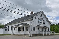
 Town hall | |
 Location in Grafton County, New Hampshire | |
| Coordinates: 43°36′41″N 71°47′34″W / 43.61139°N 71.79278°W | |
| Country | United States |
| State | New Hampshire |
| County | Grafton |
| Incorporated | 1782 |
| Government | |
| • Board of Selectmen | George Tuthill, Chair Robert Piehler Chet Caron |
| Area | |
• Total | 43.4 sq mi (112.3 km2) |
| • Land | 43.2 sq mi (111.8 km2) |
| • Water | 0.2 sq mi (0.5 km2) 0.47% |
| Elevation | 623 ft (190 m) |
| Population (2020)[2] | |
• Total | 1,776 |
| • Density | 41/sq mi (15.9/km2) |
| Time zone | UTC-5 (Eastern) |
| • Summer (DST) | UTC-4 (Eastern) |
| ZIP codes | |
| Area code | 603 |
| FIPS code | 33-00580 |
| GNIS feature ID | 0873527 |
| Website | www |
Alexandria is a town in Grafton County, New Hampshire, United States. The population was 1,776 at the 2020 census,[2] up from 1,613 at the 2010 census.[3] Newfound Lake is in the northeast corner, with Wellington State Park on the western shore. The town is home to Welton Falls State Forest. Cardigan Mountain State Park, with Mount Cardigan, is in the west. Another attraction is Mowglis Mountain, named for Rudyard Kipling's Jungle Book hero.
- ^ "2021 U.S. Gazetteer Files – New Hampshire". United States Census Bureau. Retrieved November 18, 2021.
- ^ a b "Alexandria town, Grafton County, New Hampshire: 2020 DEC Redistricting Data (PL 94-171)". U.S. Census Bureau. Retrieved November 18, 2021.
- ^ United States Census Bureau, American FactFinder, 2010 Census figures. Retrieved March 23, 2011.