Back أناكورتس Arabic اناكورتس ARZ اناکورتز، واشینقتون AZB Анакортъс Bulgarian Anacortes Catalan Анакортес (Вашингтон) CE Anacortes CEB Anacortes Czech Anacortes, Washington CY Anacortes DAG
Anacortes, Washington | |
|---|---|
 View of the downtown and marina of Anacortes from Cap Sante, c. 2006 | |
 | |
| Coordinates: 48°30′7″N 122°37′25″W / 48.50194°N 122.62361°W | |
| Country | United States |
| State | Washington |
| County | Skagit |
| Government | |
| • Type | Mayor–council |
| • Mayor | Matthew Miller |
| Area | |
• Total | 15.65 sq mi (40.53 km2) |
| • Land | 11.70 sq mi (30.30 km2) |
| • Water | 3.95 sq mi (10.23 km2) |
| Elevation | 23 ft (7 m) |
| Population | |
• Total | 17,637 |
• Estimate (2021)[3] | 17,832 |
| • Density | 1,498.16/sq mi (578.45/km2) |
| Time zone | UTC-8 (PST) |
| • Summer (DST) | UTC-7 (PDT) |
| ZIP code | 98221 |
| Area code | 360 |
| FIPS code | 53-01990 |
| GNIS feature ID | 1511964[4] |
| Website | cityofanacortes |
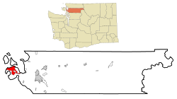
Anacortes (/ˌænəˈkɔːrtəs/ AN-ə-KOR-təs) is a city in Skagit County, Washington, United States. The name "Anacortes" is an adaptation of the name of Anne Curtis Bowman, who was the wife of early Fidalgo Island settler Amos Bowman.[5] Anacortes' population was 17,637 at the time of the 2020 census.[2] It is one of two principal cities of and included in the Mount Vernon-Anacortes Metropolitan Statistical Area.
Anacortes is known for the Washington State Ferries dock and terminal serving Lopez Island, Shaw Island, Orcas Island, and San Juan Island. There is also a Skagit County-operated ferry that serves Guemes Island, a residential island located across Guemes Channel, north of Anacortes.
- ^ "2019 U.S. Gazetteer Files". United States Census Bureau. Retrieved August 7, 2020.
- ^ a b "Explore Census Data". United States Census Bureau. Retrieved June 22, 2022.
- ^ Cite error: The named reference
USCensusEst2021was invoked but never defined (see the help page). - ^ "US Board on Geographic Names". United States Geological Survey. October 25, 2007. Retrieved January 31, 2008.
- ^ "Historical Timeline." Anacortes History Museum. July 10, 2006. Retrieved on August 14, 2007.
