Back مقاطعة آستارا Arabic Astara rayonu AZ آستارا رایونو AZB Астарынскі раён BE-X-OLD Astara BR Districte d'Astara Catalan Астаран кӀошт CE Astara District CEB Astara (rayon) CRH Astara (rajón) Czech
This article needs additional citations for verification. (November 2023) |
Astara District
Astara rayonu | |
|---|---|
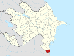
 Map of Azerbaijan showing Astara District | |
| Country | |
| Region | Lankaran-Astara |
| Established | 8 August 1930 |
| Capital | Astara |
| Settlements[1] | 92 |
| Government | |
| • Governor | Gazanfar Aghayev |
| Area | |
• Total | 620 km2 (240 sq mi) |
| Population | |
• Total | 110,000 |
| • Density | 180/km2 (460/sq mi) |
| Time zone | UTC+4 (AZT) |
| Postal code | 0700 |
| Website | astara-ih |
Astara District (Azerbaijani: Astara rayonu) is one of the 66 districts of Azerbaijan. It is located in the southeast of the country, in the Lankaran-Astara Economic Region. The district borders the districts of Lankaran and Lerik, as well as the Ardabil and Gilan provinces of Iran. Its capital and largest city is Astara. As of 2020, the district had a population of 110,000.[2]
- ^ "İnzibati-ərazi vahidləri" (PDF). preslib.az. Retrieved 28 February 2021.
- ^ a b "Population of Azerbaijan". stat.gov.az. State Statistics Committee. Retrieved 22 February 2021.