Back Australies-Antarktiese Gebied AF Territorio Antarctico Australiano AN الإقليم الأسترالي في القارة القطبية الجنوبية Arabic Territoriu Antárticu Australianu AST Avstraliyanın Antarktika ərazisi AZ Аўстралійская антарктычная тэрыторыя BE Аўстралійская антарктычная тэрыторыя BE-X-OLD Австралийска антарктическа територия Bulgarian Douaroù antarktikel aostralian BR Australijska antarktička teritorija BS
Australian Antarctic Territory | |
|---|---|
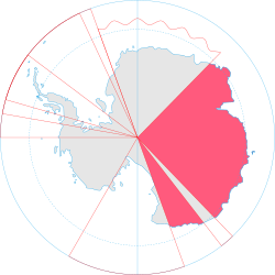
 Map of Antarctica indicating Australian territorial claim (red area) | |
| Sovereign state | |
| British claim | 1841 |
| Claim transferred to Australia | 1933 |
| Main base and administrative centre | Davis Station 68°34′36″S 77°58′03″E / 68.576667°S 77.9675°E |
| Official languages | English |
| Government | Dependency under a constitutional monarchy |
• Monarch | Charles III |
| Sam Mostyn | |
• Australian government minister | Tanya Plibersek |
• Chief Scientist | Nicole Webster |
| Area | |
• Total | 5,896,500 km2 (2,276,700 sq mi) |
| Population | |
• Estimate | less than 1,000 |
| Currency | Australian dollar (AU$) (AUD) |
| Calling code | +672 1x |
| Internet TLD | |
The Australian Antarctic Territory (AAT) is a part of East Antarctica claimed by Australia as an external territory. It is administered by the Australian Antarctic Division, an agency of the federal Department of Climate Change, Energy, the Environment and Water. The territory's history dates to a claim on Enderby Land made by the United Kingdom in 1841, which was subsequently expanded and eventually transferred to Australia in 1933. It is the largest Antarctica claimed by any by area. Australia is an original signatory to the Antarctic Treaty of 1961. Under section 4, all territorial claims are held in abeyance. Only four other countries accept Australia's claim to sovereignty, being New Zealand, the United Kingdom, France and Norway, all of whom have territorial claims in Antarctica and mutually accept each other’s claims.[1]
- ^ Humane Society International Inc v Kyodo Senpaku Kaisha Ltd FCA 3 (15 January 2008), Federal Court of Australia, §13.