Back Bandelier National Monument CEB Cofeb Genedlaethol Bandelier CY Bandelier National Monument German Bandelier National Monument French Bandelier National Monument Italian 반델리어 국립기념물 Korean ബാൻഡെലിയർ ദേശീയ സ്മാരകസൗധം Malayalam Bandelier National Monument Polish Бандельер Russian Bandelier nationalmonument Swedish
| Bandelier National Monument | |
|---|---|
IUCN category V (protected landscape/seascape) | |
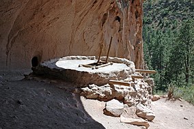
 Reconstructed kiva at Alcove House | |
| Location | Sandoval, Los Alamos and Santa Fe counties, New Mexico, United States |
| Nearest town | Los Alamos, New Mexico |
| Coordinates | 35°46′44″N 106°19′16″W / 35.77889°N 106.32111°W[1] |
| Area | 33,677 acres (136.29 km2)[2] |
| Created | February 11, 1916 |
| Visitors | 210,941 (in 2022)[3] |
| Governing body | National Park Service |
| Website | Bandelier National Monument |
Bandelier National Monument | |
| Built | 1200 |
| NRHP reference No. | 66000042[4] (original) 14001017[5] (increase) |
| NMSRCP No. | 56 |
| Significant dates | |
| Added to NRHP | October 15, 1966 |
| Boundary increase | December 10, 2014 |
| Designated NMSRCP | May 21, 1971 |

Bandelier National Monument is a 33,677-acre (136 km2) United States National Monument near Los Alamos in Sandoval and Los Alamos counties, New Mexico. The monument preserves the homes and territory of the Ancestral Puebloans of a later era in the Southwest. Most of the pueblo structures date to two eras, dating between AD 1150 and 1600.
The monument is 50 square miles (130 km2) of the Pajarito Plateau, on the slopes of the Jemez volcanic field in the Jemez Mountains. Over 70% of the monument is wilderness, with over one mile of elevation change, from about 5,000 feet (1,500 m) along the Rio Grande to over 10,000 feet (3,000 m) at the peak of Cerro Grande on the rim of the Valles Caldera, providing for a wide range of life zones and wildlife habitats. 3 miles (5 km) of road and more than 70 miles (110 km) of hiking trails are built. The monument protects Ancestral Pueblo archeological sites, a diverse and scenic landscape, and the country's largest National Park Service Civilian Conservation Corps National Landmark District. Two-thirds of the park, 23,267 acres (9,416 ha), is designated as the Bandelier Wilderness Area. Motorized travel and permanent structures are forbidden in the Wilderness.
Bandelier was designated by President Woodrow Wilson as a national monument on February 11, 1916, and named for Adolph Bandelier, a Swiss-American anthropologist, who researched the cultures of the area and supported preservation of the sites. The park infrastructure was developed in the 1930s by crews of the Civilian Conservation Corps and is a National Historic Landmark for its well-preserved architecture. The National Park Service cooperates with surrounding Pueblos, other federal agencies, and state agencies to manage the park.
- ^ "Bandelier National Monument". Geographic Names Information System. United States Geological Survey, United States Department of the Interior. Retrieved November 18, 2013.
- ^ "Listing of acreage – December 31, 2011" (XLSX). Land Resource Division, National Park Service. Retrieved 2012-03-12. (National Park Service Acreage Reports)
- ^ "Annual Park Ranking Report for Recreation Visits in: 2022". nps.gov. National Park Service. Retrieved August 5, 2023.
- ^ "National Register Information System". National Register of Historic Places. National Park Service. July 9, 2010.
- ^ Weekly List of Actions Taken on Properties: 12/08/14 through 12/12/14 (Report). National Park Service. December 19, 2014.

