Back بنيسيا (كاليفورنيا) Arabic بنيسيا (كاليفورنيا) ARZ بنیسیا، کالیفورنیا AZB Бъниша Bulgarian Benicia Catalan Бениша (Калифорни) CE Benicia CEB Benicia German Benicia Spanish Benicia (Kalifornia) EU
Benicia | |
|---|---|
| City of Benicia | |
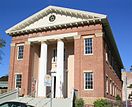
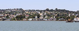
Portuguese Hall of Benicia View from the Carquinez Strait | |
| Motto: "It’s better in Benicia" | |
| Country | United States |
| State | California |
| County | Solano |
| Incorporated | March 27, 1850[1] |
| Government | |
| • Mayor | Steve Young[2] |
| • State senator | Christopher Cabaldon (D)[3] |
| • Assemblymember | Buffy Wicks (D)[3] |
| • U. S. rep. | John Garamendi (D)[4] |
| Area | |
• Total | 14.12 sq mi (36.57 km2) |
| • Land | 12.81 sq mi (33.19 km2) |
| • Water | 1.31 sq mi (3.39 km2) 17.75% |
| Elevation | 26 ft (8 m) |
| Population (2020) | |
• Total | 27,131 |
| • Density | 2,117.46/sq mi (817.56/km2) |
| Time zone | UTC−8 (Pacific) |
| • Summer (DST) | UTC−7 (PDT) |
| ZIP Code | 94510 |
| Area code | 707 |
| FIPS code | 06-05290 |
| GNIS feature IDs | 0277472, 2409833 |
| Website | www |
Benicia (/bəˈniːʃə/ buh-NISH-A, Spanish: [beˈnisja]) is a city in Solano County, California, located on the north bank of the Carquinez Strait in the North Bay region of the San Francisco Bay Area. It served as the capital of California for nearly thirteen months from 1853 to 1854. The population was 27,131 at the 2020 United States Census. Benicia is just east of Vallejo and across the strait from Martinez.
- ^ "California Cities by Incorporation Date". California Association of Local Agency Formation Commissions. Archived from the original (Word) on November 3, 2014. Retrieved August 25, 2014.
- ^ "City Council". City of Benicia. Retrieved September 20, 2021.
- ^ a b "Statewide Database". UC Regents. Retrieved December 5, 2020.
- ^ "California's 8th Congressional District - Representatives & District Map". Civic Impulse, LLC.
- ^ "2020 U.S. Gazetteer Files". United States Census Bureau. Retrieved October 30, 2021.
- ^ "Benicia". Geographic Names Information System. United States Geological Survey, United States Department of the Interior. Retrieved October 20, 2014.


