Back Beringstraat AF Beringstraße ALS Estreito de Bering AN مضيق بيرنغ Arabic لمضيق د بيرينݣ ARY بيرينج ARZ Estrechu de Bering AST Bering Vedil AVK Berinq boğazı AZ Беринг боғаҙы BA
| Bering Strait | |
|---|---|
 The Bering Strait | |
 Nautical chart of the Bering Strait | |
| Location | North Asia and Northern America |
| Coordinates | 65°45′00″N 168°58′37″W / 65.75000°N 168.97694°W |
| Basin countries | Russia, United States |
| Min. width | 82 km (51 mi) |
| Average depth | 30–50 m (98–164 ft) |
| Max. depth | 90 m (300 ft) |
| Islands | Diomede Islands |
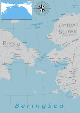
The Bering Strait (Russian: Берингов пролив, romanized: Beringov proliv) is a strait between the Pacific and Arctic oceans, separating the Chukchi Peninsula of the Russian Far East from the Seward Peninsula of Alaska. The present Russia–United States maritime boundary is at 168° 58' 37" W longitude, slightly south of the Arctic Circle at about 65° 40' N latitude. The Strait is named after Vitus Bering, a Danish-born Russian explorer.
The Bering Strait has been the subject of the scientific theory that humans migrated from Asia to North America across a land bridge known as Beringia when lower ocean levels – a result of glaciers locking up vast amounts of water – exposed a wide stretch of the sea floor,[1] both at the present strait and in the shallow sea north and south of it. This view of how Paleo-Indians entered America has been the dominant one for several decades and continues to be the most accepted one. Numerous successful crossings without the use of a boat have also been recorded since at least the early 20th century.
- ^ Beck, Roger B.; Linda Black; Larry S. Krieger; Phillip C. Naylor; Dahia Ibo Shabaka (1999). World History: Patterns of Interaction. Evanston, IL: McDougal Littell. ISBN 978-0-395-87274-1.
