Back Boxtel AN بوكستل Arabic Boxtel Catalan Gemeente Boxtel CEB Boxtel Danish Boxtel German Boxtel EO Boxtel Spanish Boxtel EU بوکستل FA
Boxtel | |
|---|---|
Town and municipality | |
 Boxtel town centre | |
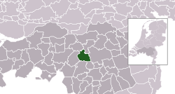
 Location in North Brabant | |
| Coordinates: 51°35′N 5°20′E / 51.583°N 5.333°E | |
| Country | Netherlands |
| Province | North Brabant |
| Government | |
| • Body | Municipal council |
| • Mayor | Ronald van Meygaarden (None) |
| Area | |
• Total | 64.85 km2 (25.04 sq mi) |
| • Land | 63.73 km2 (24.61 sq mi) |
| • Water | 1.12 km2 (0.43 sq mi) |
| Elevation | 8 m (26 ft) |
| Population (January 2021)[3] | |
• Total | 32,973 |
| • Density | 517/km2 (1,340/sq mi) |
| Demonym(s) | Boxelaar, Boxtelaar |
| Time zone | UTC+1 (CET) |
| • Summer (DST) | UTC+2 (CEST) |
| Postcode | 5280–5283, 5298 |
| Area code | 0411 |
| Website | www |
Boxtel (Dutch pronunciation: [ˈbɔkstəl]) is a municipality and a town in southern Netherlands. The name derives from Buchestelle and is presumably a combination of 'stelle' (Dutch for stable, safe place) and (deer) buck.[4]
This is the origin of the Van Boxtel family, which has numerous descendants in North Brabant.
The town was the site of the Battle of Boxtel fought in September 1794 during the Flanders campaign. It is often principally remembered as the first battle of the future Duke of Wellington Arthur Wellesley.
- ^ "Kerncijfers wijken en buurten 2020" [Key figures for neighbourhoods 2020]. StatLine (in Dutch). CBS. 24 July 2020. Retrieved 19 September 2020.
- ^ "Postcodetool for 5281AT". Actueel Hoogtebestand Nederland (in Dutch). Het Waterschapshuis. Retrieved 7 May 2014.
- ^ "Bevolkingsontwikkeling; regio per maand" [Population growth; regions per month]. CBS Statline (in Dutch). CBS. 1 January 2021. Retrieved 2 January 2022.
- ^ 2019. Etymologiebank.Nl. Accessed April 27 2019. [1].
