Back Broadland CEB Ardal Broadland CY Broadland German Broadland Spanish Broadland French Broadland Italian 브로들랜드 Korean Brodlenda Latvian/Lettish Broadland Dutch Broadland NB
Broadland District | |
|---|---|
 | |
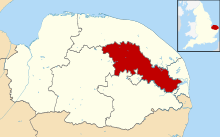
 Broadland shown within Norfolk | |
| Sovereign state | United Kingdom |
| Constituent country | England |
| Region | East of England |
| Non-metropolitan county | Norfolk |
| Status | Non-metropolitan district |
| Incorporated | 1 April 1974 |
| Government | |
| • Type | Non-metropolitan district council |
| • Body | Broadland District Council |
| • MPs | Jerome Mayhew Alice Macdonald |
| Area | |
• Total | 213.3 sq mi (552.4 km2) |
| • Rank | 70th (of 296) |
| Population (2022) | |
• Total | 133,872 |
| • Rank | 178th (of 296) |
| • Density | 630/sq mi (240/km2) |
| Ethnicity (2021) | |
| • Ethnic groups | |
| Religion (2021) | |
| • Religion | List
|
| Time zone | UTC0 (GMT) |
| • Summer (DST) | UTC+1 (BST) |
| ONS code | 33UC (ONS) E07000144 (GSS) |
| OS grid reference | TG2682109307 |
Broadland is a local government district in Norfolk, England, named after the Norfolk Broads. Its council is based at the Broadland Business Park on the outskirts of Norwich. The district includes the towns of Acle, Aylsham, Reepham, Sprowston and Thorpe St Andrew. Several of the district's settlements (including Sprowston and Thorpe St Andrew) form part of the Norwich built-up area, lying outside the city's boundaries to the north-west and north-east. The district also includes numerous villages and surrounding rural areas. Some eastern parts of the district lie within The Broads.
The neighbouring districts are North Norfolk, Great Yarmouth, South Norfolk, Norwich and Breckland.
In 2013, Broadland was ranked as the most peaceful locality within the United Kingdom, having the lowest level of violent crime in the country.[2]
- ^ a b UK Census (2021). "2021 Census Area Profile – Broadland Local Authority (E07000144)". Nomis. Office for National Statistics. Retrieved 5 January 2024.
- ^ "Screen Shot 2013-04-24 at 10.49.34 AM.PNG | View photo - Yahoo! News UK". Archived from the original on 27 April 2013. Retrieved 24 April 2013.