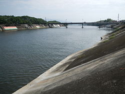
| Calumpang River | |
|---|---|
 Calumpang River in Batangas City | |
Calumpang River mouth | |
| Location | |
| Country | Philippines |
| Region | Calabarzon |
| Province | Batangas |
| City/municipality | |
| Physical characteristics | |
| Source | |
| • location | Rosario, Batangas |
| Mouth | |
• location | Batangas Bay |
• coordinates | 13°44′13″N 121°03′30″E / 13.73694°N 121.05820°E |
• elevation | 0 m (0 ft) |
| Basin size | 472 km2 (182 sq mi)[1] |
| Discharge | |
| • location | Batangas Bay |
The Calumpang River (Tagalog: Ilog Calumpang) is a major river in eastern Batangas, Philippines. Known as the "Nile of Batangas," the river itself forms the southeastern boundary of Poblacion, Batangas City as it continues to flow southward to Batangas Bay at an approximately point of 2 kilometres (1.2 mi) east of Batangas Port.[1][2]
The river may derive its name from Sterculia foetida, a tree which whose local name is alternately spelled calumpang or kalumpang in Tagalog.[3]
- ^ a b Cite error: The named reference
batangascity.gov.ph(2)was invoked but never defined (see the help page). - ^ Cite error: The named reference
thelathewas invoked but never defined (see the help page). - ^ Cite error: The named reference
wowbatangas.com(1)was invoked but never defined (see the help page).


