| Carbonera Creek | |
|---|---|
 Confluence of Carbonera Creek and Branciforte Creek | |
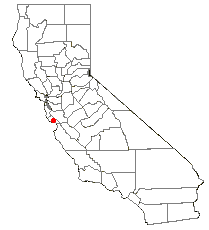
 Location of Carbonera Creek in California | |
| Location | |
| Country | United States |
| State | California |
| Region | Santa Cruz County |
| Physical characteristics | |
| Source | Santa Cruz Mountains |
| • location | near Laurel, California |
| • coordinates | 37°5′23.81″N 121°58′47.86″W / 37.0899472°N 121.9799611°W[1] |
| • elevation | 1,123 ft (342 m) |
| Mouth | Branciforte Creek |
• location | Santa Cruz |
• coordinates | 36°58′26.82″N 122°1′19.87″W / 36.9741167°N 122.0221861°W[1] |
• elevation | 7 ft (2.1 m)[1] |
| Length | 10.2 mi (16.4 km)[2] |
| Basin size | 7.4 sq mi (19 km2)[3] |
| Basin features | |
| Tributaries | |
| • right | Camp Evers Creek |

Carbonera Creek is a 10.2-mile-long (16.4 km) watercourse in Santa Cruz County, California, that eventually flows to the San Lorenzo River.
The stream rises in the rugged Santa Cruz Mountains and flows in a generally southwesterly direction. The city of Scotts Valley is situated within the watershed of Carbonera Creek and its main tributary to the north, Bean Creek. Carbonera Creek joins Branciforte Creek near the 500 block of Market Street in Santa Cruz.[4] Branciforte Creek discharges to the San Lorenzo River, which empties into the Pacific Ocean at Monterey Bay at Santa Cruz.[5]
The perennial Carbonera Creek has a watershed of 7.4 square miles (19 km2). The West Branch of Carbonera Creek is a total of 1.4 miles (2.3 km) in length and passes under Vine Hill Road. The West Branch continues under Scotts Valley Drive and the State Route 17/Granite Creek Interchange through a series of box culverts. The West Branch joins the main branch of Carbonera Creek immediately south of the State Route 17/Granite Creek Interchange. Carbonera Creek is the major surface water hydrological feature in Scotts Valley, running across the western portion of the Santa's Village site and through the center of town.
- ^ a b c U.S. Geological Survey Geographic Names Information System: Carbonera Creek
- ^ U.S. Geological Survey. National Hydrography Dataset high-resolution flowline data. The National Map Archived 2012-03-29 at the Wayback Machine, accessed March 15, 2011
- ^ Marc Papineau, C. Michael Hogan, ballard George et al., Environmental Impact Report for the Scotts Valley Redevelopment Area, Earth Metrics Incorporated, State of California Clearinghouse Report 7888 (1990)
- ^ "36°59'11.9"N 122°00'51.0"W".
- ^ USGS Quadrangle Map, U.S. Government Printing Office, Washington, DC, 1980)
