Back مقاطعة كارول (فيرجينيا) Arabic Carroll County, Virginia BAR Керъл (окръг, Вирджиния) Bulgarian কেরোল কাউন্টি, ভার্জিনিয়া BPY Carroll Gông (Virginia) CDO Кэрролл (гуо, Виргини) CE Carroll County (kondado sa Tinipong Bansa, Virginia) CEB Carroll County (Virginie) Czech Carroll County, Virginia CY Carroll County (Virginia) German
Carroll County | |
|---|---|
 Carroll County Courthouse and Confederate Monument | |
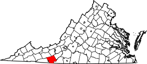
 Location within the U.S. state of Virginia | |
 Virginia's location within the U.S. | |
| Coordinates: 36°44′N 80°44′W / 36.73°N 80.73°W | |
| Country | |
| State | |
| Founded | 1842 |
| Named for | Charles Carroll |
| Seat | Hillsville |
| Largest town | Hillsville |
| Area | |
• Total | 478 sq mi (1,240 km2) |
| • Land | 475 sq mi (1,230 km2) |
| • Water | 3 sq mi (8 km2) 0.6% |
| Population (2020) | |
• Total | 29,155 |
| • Density | 61/sq mi (24/km2) |
| Time zone | UTC−5 (Eastern) |
| • Summer (DST) | UTC−4 (EDT) |
| Congressional district | 9th |
| Website | www |
Carroll County is a United States county located in the southwestern part of the Commonwealth of Virginia. Roughly one fifth of the county lies in the Virginia Piedmont region, while the rest is part of the Appalachian Mountains. The county seat and only town is Hillsville.[1]
The county was established in 1842 from part of Grayson County, and was officially named in honor of Charles Carroll, a signer of the Declaration of Independence. The borders of Carroll County were later expanded by including land from Patrick County.
The total size of the county is 478 square miles (1,240 km2), and, as of the 2020 census, the population was 29,155.[2]
- ^ "Find a County". National Association of Counties. Archived from the original on May 31, 2011. Retrieved June 7, 2011.
- ^ "Carroll County, Virginia". United States Census Bureau. Retrieved January 30, 2022.
