34°25′10″N 118°37′48″W / 34.41944°N 118.63000°W[1]
| Castaic Creek | |
|---|---|
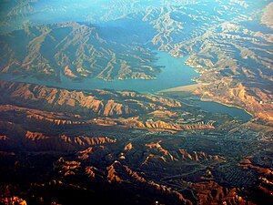
 Castaic Lake, with Castaic Lagoon and lower Castaic Creek in center-right side. | |
 | |
| Location | |
| Country | United States |
| State | California |
| Region | Los Angeles County |
| Physical characteristics | |
| Source | |
| • location | Lake Hughes |
| Mouth | |
• location | confluence with Santa Clara River at Castaic Junction |
• coordinates | [1] |
| Length | 25 mi (40 km) |
| Basin features | |
| River system | Santa Clara River |
Castaic Creek (Chumash: Kaštiq)[2] is a 25.0-mile-long (40.2 km)[3] stream in the Sierra Pelona Mountains, in northeastern Los Angeles County, California. It is a tributary of the Santa Clara River.
- ^ a b "Castaic Creek". Geographic Names Information System. United States Geological Survey, United States Department of the Interior.
- ^ Chumash Place Names
- ^ "U.S. Geological Survey. National Hydrography Dataset high-resolution flowline data". The National Map. Archived from the original on 2012-03-29., accessed March 16, 2011
