Back Catawba County, Noord-Carolina AF مقاطعة كاتاوبا (كارولاينا الشمالية) Arabic Catawba County, North Carolina BAR Кътоуба (окръг, Северна Каролина) Bulgarian কাটাৱাবা কাউন্টি, নর্থ ক্যারোলাইনা BPY Catawba Gông (North Carolina) CDO Катоба (гуо, Къилбаседа Каролина) CE Catawba County CEB Catawba County, Gogledd Carolina CY Catawba County German
Catawba County | |
|---|---|
 | |
| Motto: "Making. Living. Better." | |
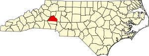
 Location within the U.S. state of North Carolina | |
 North Carolina's location within the U.S. | |
| Coordinates: 35°40′N 81°13′W / 35.66°N 81.21°W | |
| Country | |
| State | |
| Founded | 1842 |
| Named for | Catawba Tribe |
| Seat | Newton |
| Largest community | Hickory |
| Area | |
• Total | 416.02 sq mi (1,077.5 km2) |
| • Land | 401.37 sq mi (1,039.5 km2) |
| • Water | 14.65 sq mi (37.9 km2) 3.52% |
| Population (2020) | |
• Total | 160,610 |
• Estimate (2023) | 164,645 |
| • Density | 400.15/sq mi (154.50/km2) |
| Time zone | UTC−5 (Eastern) |
| • Summer (DST) | UTC−4 (EDT) |
| Congressional district | 10th |
| Website | www |
Catawba County (/kəˈtɔːbə/ kuh-TAW-buh)[1] is a county in the U.S. state of North Carolina. As of the 2020 census, the population was 160,610.[2] Its county seat is Newton,[3] and its largest community is Hickory.
The county is part of the Hickory-Lenoir-Morganton, NC Metropolitan Statistical Area.
- ^ "Catawba". Dictionary.com. Retrieved August 22, 2023.
- ^ Cite error: The named reference
2020CensusQuickFactswas invoked but never defined (see the help page). - ^ "Find a County". National Association of Counties. Archived from the original on May 31, 2011. Retrieved June 7, 2011.


