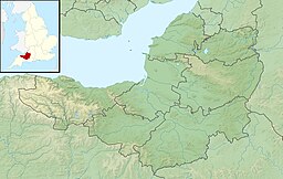
| Clatworthy Reservoir | |
|---|---|
 | |
| Location | Somerset |
| Coordinates | 51°04′23″N 3°22′9″W / 51.07306°N 3.36917°W |
| Type | reservoir |
| Primary inflows | River Tone |
| Basin countries | United Kingdom |
| Water volume | 5,364,000 cubic metres (1.180×10⁹ imp gal) |
Clatworthy Reservoir is situated near Clatworthy in the Brendon Hills on the edge of the Exmoor National Park in west Somerset, England. It is run by Wessex Water and has a capacity of 5,364,000 cubic metres (1.180×10⁹ imp gal),[1] supplying some 200,000 homes. It impounds the head waters of the River Tone and the surrounding area is used for walking and fishing.
Clatworthy Camp, an Iron Age hill fort is situated on a promontory above Clatworthy Reservoir. It is roughly triangular in shape with an area of 5.8 hectares. It has a single bank and ditch, cut through solid rock. There may have been an entrance on the west and two on the east.[2] The ancient settlement of Syndercombe was flooded on the creation of the reservoir. In the Domesday Book of 1086 the manor of Syndercombe is recorded as held by Turstin FitzRolf.[3]
- ^ "Hydrological Summary for the United Kingdom" (PDF). The Centre for Ecology & Hydrology. Archived from the original (PDF) on 26 July 2011. Retrieved 10 January 2009.
- ^ "Clatworthy Camp Hillfort". Digital Digging. Archived from the original on 11 August 2010. Retrieved 27 August 2010.
- ^ "Home". domesdaybook.co.uk.

