| Comb Ridge Tséyíkʼáán (in Navajo) | |
|---|---|
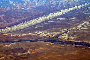
 Comb Ridge from the air, above Bluff Utah and the San Juan River | |
 | |
| Location | Utah and Arizona |
| Nearest city | Blanding, Utah |
| Coordinates | 37°25′39″N 109°38′47″W / 37.42750°N 109.64639°W |
| Designated | 1976 |

Comb Ridge (Navajo: Tséyíkʼáán)[1] is a linear north to south-trending monocline nearly 80 miles long in Southeastern Utah and Northeastern Arizona. Its northern end merges with the Abajo Mountains some eleven miles west of Blanding. It extends essentially due south for 45 km (28 mi) to the San Juan River. South of the San Juan the ridge turns to the southwest and is more subdued in expression as it extends for an additional 67 km (42 mi) to Laguna Creek 9 km (5.6 mi) east of Kayenta, Arizona.[2][3]
It was designated a National Natural Landmark in 1976 as the only North American location of tritylodont fossils.[4] Parts of the ridge in Utah are protected as part of the Bears Ears National Monument.[5]
- ^ Linford, Laurence D. Navajo Places: History, Legend, Landscape, University of Utah Press, Salt Lake City, UT 2000.
- ^ Geosights, Comb Ridge, San Juan County, Utah, May 2012, pp. 9–11 Archived 2012-11-26 at the Wayback Machine
- ^ USGS 30x60 quadrangle topographic maps: Blanding, Utah-Colorado; Bluff, Utah-Colorado; Rock Point, Arizona-New Mexico; Kayenta, Arizona
- ^ "National Natural Landmark". National Park Service. Retrieved 11 December 2012.
- ^ Obama Designates Two New National Monuments, Protecting 1.65 Million Acres. Davenport, Coral. The New York Times, 28 December 2016
