Back مقاطعة كروك (أوريغون) Arabic Crook County, Oregon BAR Крук (окръг, Орегон) Bulgarian ক্রোক কাউন্টি, অরেগন BPY Crook Gông (Oregon) CDO Крук (гуо, Орегон) CE Crook County (kondado sa Tinipong Bansa, Oregon) CEB Crook County (Oregon) Czech Crook County, Oregon CY Crook County (Oregon) German
Crook County | |
|---|---|
 Crook County Courthouse in Prineville | |
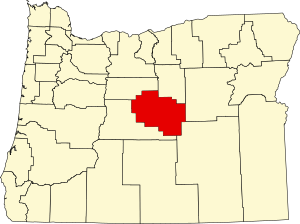
 Location within the U.S. state of Oregon | |
 Oregon's location within the U.S. | |
| Coordinates: 44°08′N 120°22′W / 44.13°N 120.36°W | |
| Country | |
| State | |
| Founded | October 24, 1882 |
| Named for | George Crook |
| Seat | Prineville |
| Largest city | Prineville |
| Area | |
• Total | 2,987 sq mi (7,740 km2) |
| • Land | 2,979 sq mi (7,720 km2) |
| • Water | 8.2 sq mi (21 km2) 0.3% |
| Population (2020) | |
• Total | 24,738 |
• Estimate (2023) | 26,952 |
| • Density | 7.0/sq mi (2.7/km2) |
| Time zone | UTC−8 (Pacific) |
| • Summer (DST) | UTC−7 (PDT) |
| Congressional district | 2nd |
| Website | co |
Crook County is one of the 36 counties in the U.S. state of Oregon. As of the 2020 census, the population was 24,738.[1] The county seat is Prineville.[2] The county is named after George Crook, a U.S. Army officer who served in the American Civil War and various Indian Wars.
Crook County comprises the Prineville, OR Micropolitan Statistical Area, which is included in the Bend—Prineville, OR Combined Statistical Area.[3]
- ^ "State & County QuickFacts". United States Census Bureau. Retrieved May 20, 2023.
- ^ "Find a County". National Association of Counties. Archived from the original on May 31, 2011. Retrieved June 7, 2011.
- ^ "OMB Bulletin No. 13-01: Revised Delineations of Metropolitan Statistical Areas, Micropolitan Statistical Areas, and Combined Statistical Areas, and Guidance on Uses of the Delineations of These Areas" (PDF). United States Office of Management and Budget. February 28, 2013. Archived (PDF) from the original on October 9, 2022. Retrieved April 8, 2013.