Back Cumulus humilis Catalan Cumulus humilis Czech Cumulus humilis Danish Cumulus humilis Spanish کومهای ناستبر FA Cumulus humilis Finnish Cumulus humilis French Awan kumulus humilis ID Cumulus humilis Italian Cumulus humilis LMO
| Cumulus humilis clouds | |
|---|---|
 | |
| Abbreviation | Cu hum |
| Symbol | |
| Genus | Cumulus (heap) |
| Species | humilis (humble) |
| Variety |
|
| Altitude | 200-2000 m (656–7,000 ft) |
| Classification | Family C (Low-level) |
| Appearance | Low-altitude, flattened, wider than it is tall, fluffy heaps of clouds with cotton-like appearance. |
| Precipitation | Uncommon Rain, Snow or Snow pellets |
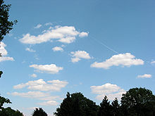
Cumulus humilis are cumuliform clouds with little vertical extent, common in the summer, that are often referred to as "fair weather cumulus". If they develop into cumulus mediocris or cumulus congestus, thunderstorms could form later in the day.[1]
They generally form at lower altitudes (500–3000 m (1,500–10,000 ft)), but in hot countries or over mountainous terrain these clouds can occur at an altitude of up to 6,000 m (20,000 ft). They show no significant vertical development, indicating that the temperature in the atmosphere above them either drops off very slowly or not at all with altitude; that is, the environmental lapse rate is small or negative. Cumulus humilis clouds often have little variance in their depths due to their constrained vertical development.[2] Cumulus humilis may be accompanied by other cloud types.
Air below the cloud base can be quite turbulent due to the thermals that formed the clouds, giving occupants of light aircraft an uncomfortable ride.[3] To avoid turbulence where such clouds are present, pilots may climb above the cloud tops. However, glider pilots actively seek out the rising air to gain altitude.
These clouds may later metamorphose into cumulus mediocris and eventually cumulus congestus clouds when convection is intense enough,[4] though the presence of these types of clouds usually indicates fair weather.[1]
- ^ a b "Windows2Universe".
- ^ "Cumulus Humilis". Earthdata. NASA. Retrieved 2023-01-04.
- ^ "NOAA Turbulence Guide". Retrieved 2018-06-03.
- ^ "Cumulus mediocris". Retrieved 2018-06-03.