Back إقليم تومبيس Arabic Tumpis jach'a suyu AY Тумбес (рэгіён) BE Тумбэс (дэпартамэнт) BE-X-OLD Тумбес (регион) Bulgarian Regió de Tumbes Catalan Tumbes (rehiyon) CEB Tumbes (region) Danish Region Tumbes German Departemento Tumbes EO
Tumbes
Departamento de Tumbes (Spanish) | |
|---|---|
 | |
 Location of the Tumbes Region in Peru | |
| Coordinates: 3°53′S 80°35′W / 3.88°S 80.59°W | |
| Country | Peru |
| Subdivisions | 3 provinces and 12 districts |
| Capital | Tumbes |
| Government | |
| • Governor | Wilmer Dios Benites (2019–2022) |
| Area | |
• Total | 4,045.86 km2 (1,562.12 sq mi) |
| Elevation (Capital) | 7 m (23 ft) |
| Highest elevation | 134 m (440 ft) |
| Lowest elevation | 0 m (0 ft) |
| Population (2017) | |
• Total | 224,863 |
| • Density | 56/km2 (140/sq mi) |
| UBIGEO | 24 |
| Dialing code | 072 |
| ISO 3166 code | PE-TUM |
| Principal resources | Petroleum, tobacco, bananas and fishing. |
| Poverty rate | 46.8% |
| Percentage of Peru's GDP | 0.49% |
| Website | www.regiontumbes.gob.pe |

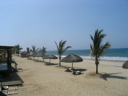
Tumbes (Spanish pronunciation: [ˈtumbes]) is a coastal department and region in northwestern Peru bordering Ecuador. Due to the region's location near the Equator it has a warm climate, with beaches that are considered among the finest in Peru. [citation needed] Despite its small area, the region contains a wide variety of ecosystems. It is the smallest department in Peru and its third least populous department after Moquegua and Madre de Dios, but it is also its third most densely populated department, after La Libertad and Lambayeque.
The name "Tumbes" originates from either Tumpis, a group of native peoples from the area, the word tumbos, a species of Passiflora that used to abound in the area, or the name of the Tumba cacique, whose son founded and populated the area.

