Back धनबाद जिला BH ধানবাদ জেলা Bengali/Bangla Dhānbād CEB Dhanbad (Distrikt) German Distrito de Dhanbad Spanish Dhanbad barrutia EU بخش دهنبد FA District de Dhanbad French ધનબાદ જિલ્લો GU धनबाद जिला HI
This article needs additional citations for verification. (December 2009) |
Dhanbad district | |
|---|---|
From Top: Maithon Dam, RamRaj Mandir(Baghmara) , Dhanbad village area | |
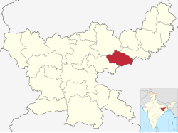
 Location of Dhanbad district in Jharkhand | |
| Country | |
| State | |
| Division | North Chotanagpur |
| Headquarters | Dhanbad |
| Government | |
| • Deputy Commissioner | Miss Madhvi Mishra (IAS) |
| • Senior Superintendent of police | Shri Hrudeep P Janardhanan (IPS) |
| • Lok Sabha constituencies | Dhanbad |
| • MP | Dhulu Mahtho (BJP) |
| • Vidhan Sabha constituencies | 6 |
| Area | |
• Total | 2,040 km2 (790 sq mi) |
| Population (2011) | |
• Total | 2,684,487 |
| • Density | 1,300/km2 (3,400/sq mi) |
| • Urban | 1,560,394 |
| Languages | |
| • Official | Hindi |
| Demographics | |
| • Literacy | 74.52 per cent |
| • Sex ratio | 908 |
| Time zone | UTC+05:30 (IST) |
| Major highways | NH 19 NH 419 |
| Website | dhanbad |
Dhanbad district is one of the twenty-four districts of Jharkhand state, India, and Dhanbad is the administrative headquarters of this district.[1] As of 2011, it is the second most populous district of Jharkhand (out of 24), after Ranchi. It also has the lowest sex ratio in Jharkhand, at 908.[2]
Dhanbad is also known as the coal capital of India, due to extensive coal mining industry that dominates the district.[3]
- ^ "District Dhanbad, Government of Jharkhand | Coal Capital of India | India". Retrieved 3 July 2024.
- ^ "District Census Handbook: Dhanbad" (PDF). censusindia.gov.in. Registrar General and Census Commissioner of India. 2011.
- ^ "Coal capital turns Pollution capital". Centre for Science and Environment. Retrieved 3 July 2024.


