Back Dingli Catalan Dingli (munisipyo) CEB Dingli German Ντίνγκλι Greek Dingli EO Dingli Spanish Dingli EU دینگلی FA Ħad-Dingli French Dingli Hungarian
For people with the surname, see Dingli (surname).
Dingli
Ħad-Dingli | |
|---|---|
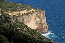
 Dingli skyline | |
| Motto(s): Non Segnis Quies Ruris (Rural quiet is not indolence) | |
 | |
| Coordinates: 35°51′37″N 14°22′53″E / 35.86028°N 14.38139°E | |
| Country | |
| Region | Northern Region |
| District | Western District |
| Borders | Rabat, Siġġiewi |
| Government | |
| • Mayor | Raymond Schembri (PL) |
| Area | |
• Total | 5.7 km2 (2.2 sq mi) |
| Elevation | 230 m (750 ft) |
| Population (Jan. 2019) | |
• Total | 3,711 |
| • Density | 650/km2 (1,700/sq mi) |
| Demonym(s) | Dingli (m), Dinglija (f), Dinglin (pl) |
| Time zone | UTC+1 (CET) |
| • Summer (DST) | UTC+2 (CEST) |
| Postal code | DGL |
| Dialing code | 356 |
| ISO 3166 code | MT-07 |
| Patron saint | Assumption of Our Lady |
| Day of festa | First Sunday after 15 August |
| Website | Official website |
| Buses 52 and 56 from Valletta terminus[1] | |


Dingli (Maltese: Ħad-Dingli) is a village in the Northern Region of Malta, with a population of 3,865 as of 2021.[2] It is 13 kilometres (8 miles) from the capital Valletta and two kilometers (1.2 miles) from the nearest town, Rabat. The village lies on a plateau some 230 metres above sea level, near the highest point of Malta. The area provides not only open sea views over the tiny, uninhabited isle of Filfla, but is also a good vantage point over Malta. The cliffs offer views of the nearby Buskett Gardens and Verdala Palace.
Cite error: There are <ref group=lower-alpha> tags or {{efn}} templates on this page, but the references will not show without a {{reflist|group=lower-alpha}} template or {{notelist}} template (see the help page).
- ^ "Malta Public Transport". Archived from the original on 10 March 2016. Retrieved 28 November 2015.
- ^ "Census of Population and Housing 2021: Preliminary Report". nso.gov.mt. Archived from the original on 7 December 2022. Retrieved 7 December 2022.

