Back دوبوي Arabic دوبوى ARZ Doboy AZ Добай BE Добай BE-X-OLD Добой Bulgarian Doboj BS Doboj Catalan Doboj (lungsod sa Bosniya ug Ersogobina) CEB Doboj Czech
Doboj
Добој (Serbian) | |
|---|---|
| Grad Doboj Град Добој City of Doboj | |
From the top to bottom-right, Panoramic View of Doboj, Doboj Fortress, Orthodox Church of the Nativity of the Blessed Virgin, View over city from the fortress walls | |
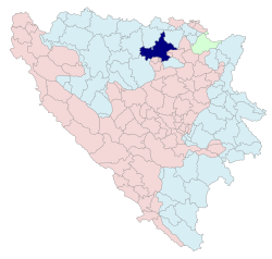
 Location of Doboj within Republika Srpska | |
 | |
| Coordinates: 44°43′53″N 18°05′04″E / 44.73139°N 18.08444°E | |
| Country | |
| Entity | |
| First written record | 28 June 1415 |
| City status | July 2012 |
| Government | |
| • Type | Mayor-council government |
| • Body | Mayor of Doboj |
| • Mayor | Boris Jerinić (SNSD) |
| Area | |
• City | 648 km2 (250 sq mi) |
| • Land | 648 km2 (250 sq mi) |
| Population (2013 census) | |
• City | 71,441 |
| • Density | 110/km2 (290/sq mi) |
| • Urban | 26,987 |
| Time zone | UTC+1 (CET) |
| • Summer (DST) | UTC+2 (CEST) |
| Area code | +387 53 |
| Website | doboj |

Doboj (Serbian Cyrillic: Добој, pronounced [dôboj])[1] is a city in Republika Srpska, Bosnia and Herzegovina. It is situated on the banks of the Bosna river, in the northern region of Republika Srpska. As of 2013, it has a population of 71,441 inhabitants.
Doboj is the largest national railway junction and the operational base of the Railways Corporation of Bosnia and Herzegovina.[2] It is one of the oldest cities in Bosnia and Herzegovina and, aside from Banja Luka, the most important urban center in northern Republika Srpska.
- ^ Mangold, Max (2005). Das Aussprachewörterbuch (in German) (6th ed.). Mannheim: Dudenverlag. p. 279. ISBN 9783411040667.
- ^ "Bosnia and Herzegovina Railways Public Corporation contact". www.bhzjk.ba. Retrieved 21 December 2022.


