Back डोकलाम BH Doklam Spanish دوکلام FA Doklam French דוקלם HE डोकलाम HI 도클람 Korean ਡੋਕਲਾਮ PA டோக்லாம் Tamil డోక్లామ్ Tegulu
Doklam
Donglang | |
|---|---|
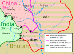
 Map of Doklam and the surrounding area | |
| Coordinates: 27°18′N 88°56′E / 27.300°N 88.933°E | |
| Range | Dongkya Range, Zompelri Ridge |
| Offshore water bodies | Doklam river |
| Area | |
| • Total | 89 square kilometres (34 sq mi) |
| Highest elevation | 4,653 metres (15,266 ft) (Merug La) |
Doklam (Tibetan: འབྲོག་ལམ, Wylie: ‘brog lam, THL: drok lam),[1][a] called Donglang (Chinese: 洞朗) by China,[5][6] is an area in Chumbi Valley with a high plateau and a valley, lying between China's Yadong County to the north, Bhutan's Ha District to the east and India's Sikkim state to the west. Since the 1960s, China and Bhutan have disputed sovereignty over the Doklam area. The dispute has not been resolved despite several rounds of border negotiations between Bhutan and China.[3][7] The area is of strategic importance to all three countries.[3][8][9]
In 1988, the Chinese People's Liberation Army entered the Doklam plateau and successfully took control of the area.[10][11] In June 2017, China attempted to extend a road on the Doklam Plateau southward, Indian troops entering the area in an attempt to stop China's construction of the road, which triggered a two-month border standoff between the two sides.[3][8][12] On 28 August, India and China withdrew their troops from the standoff in Doklam.[13] Since then, China has continued to control most of the Doklam area and built a village called Pangda there.[14][15]
- ^ a b van Driem, George L. (2021). Ethnolinguistic Prehistory: The Peopling of the World from the Perspective of Language, Genes and Material Culture. BRILL. p. 53. ISBN 978-90-04-44837-7.
- ^ Ramakrushna Pradhan, Doklam Standoff: Beyond Border Dispute, Mainstream Weekly, 29 July 2017.
- ^ a b c d Cite error: The named reference
geographywas invoked but never defined (see the help page). - ^ Sushant Singh (25 July 2017). "Simply put: Where things stand on the Dolam plateau". The Indian Express.
- ^ "Doklam standoff: China sends a warning to India over border dispute". Los Angeles Times. Associated Press. 24 July 2017. Archived from the original on 25 July 2017.
- ^ Liu Lin (27 July 2017), "India-China Doklam Standoff: A Chinese Perspective", The Diplomat, archived from the original on 29 July 2017
- ^ "Translation of the Proceedings and Resolutions of the 82nd Session of the National Assembly Of Bhutan" (PDF). June–August 2004. p. 84. Archived (PDF) from the original on 7 October 2015. Retrieved 20 July 2017.
- ^ a b Banyan (27 July 2017), "A Himalayan spat between China and India evokes memories of war", The Economist, archived from the original on 8 August 2017
- ^ "People say in Doklam, India is better placed. Why do we think Chinese could only act here? says Shyam Saran", The Indian Express, 12 August 2017, archived from the original on 13 August 2017
- ^ Cite error: The named reference
Benedictuswas invoked but never defined (see the help page). - ^ Cite error: The named reference
:0was invoked but never defined (see the help page). - ^ Walcott, Bordering the Eastern Himalaya (2010), p. 75.
- ^ Cite error: The named reference
:1was invoked but never defined (see the help page). - ^ Cite error: The named reference
:2was invoked but never defined (see the help page). - ^ Cite error: The named reference
:3was invoked but never defined (see the help page).
Cite error: There are <ref group=lower-alpha> tags or {{efn}} templates on this page, but the references will not show without a {{reflist|group=lower-alpha}} template or {{notelist}} template (see the help page).

