Back دوركينغ Arabic دورکینق AZB Dorking CEB Dorking CY Dorking Danish Dorking (Surrey) German Dorking Spanish Dorking EU دورکینگ FA Dorking French
| Dorking | |
|---|---|
| Market town | |
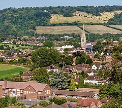
 View northeast from The Nower towards Dorking town centre and Box Hill | |
Location within Surrey | |
| Area | 6.57 km2 (2.54 sq mi) town wards[1] |
| Population | 11,158 town wards only[1] 17,098 wider built-up area[2] (2011 census) |
| • Density | 1,698/km2 (4,400/sq mi) |
| OS grid reference | TQ165494 |
| • London | 21 mi (34 km) NNE |
| District | |
| Shire county | |
| Region | |
| Country | England |
| Sovereign state | United Kingdom |
| Post town | Dorking |
| Postcode district | RH4 |
| Dialling code | 01306 |
| Police | Surrey |
| Fire | Surrey |
| Ambulance | South East Coast |
| UK Parliament | |
Dorking (/ˈdɔːrkɪŋ/) is a market town in Surrey in South East England about 21 mi (34 km) south of London. It is in Mole Valley District and the council headquarters are to the east of the centre. The High Street runs roughly east–west, parallel to the Pipp Brook and along the northern face of an outcrop of Lower Greensand. The town is surrounded on three sides by the Surrey Hills National Landscape and is close to Box Hill and Leith Hill.
The earliest archaeological evidence of human activity is from the Mesolithic and Neolithic periods, and there are several Bronze Age bowl barrows in the local area. The town may have been the site of a staging post on Stane Street during Roman times, however the name 'Dorking' suggests an Anglo-Saxon origin for the modern settlement. A market is thought to have been held at least weekly since early medieval times and was highly regarded for the poultry traded there. The Dorking breed of domestic chicken is named after the town.
The local economy thrived during Tudor times, but declined in the 17th century due to poor infrastructure and competition from neighbouring towns. During the early modern period many inhabitants were nonconformists, including the author, Daniel Defoe, who lived in Dorking as a child. Six of the Mayflower Pilgrims, including William Mullins and his daughter Priscilla, lived in the town before setting sail for the New World.
Dorking started to expand during the 18th and 19th centuries as transport links improved and farmland to the south of the centre was released for housebuilding. The new turnpike, and later the railways, facilitated the sale of lime produced in the town, but also attracted wealthier residents, who had had no previous connection to the area. Residential expansion continued in the first half of the 20th century, as the Deepdene and Denbies estates began to be broken up. Further development is now constrained by the Metropolitan Green Belt, which encircles the town.
- ^ a b Key Statistics; Quick Statistics: Population Density Archived 11 February 2003 at the Wayback Machine 2011 United Kingdom census, Office for National Statistics. Retrieved 20 December 2013
- ^ UK Census (2011). "Local Area Report – Dorking Built-up area sub division (1119884849)". Nomis. Office for National Statistics. Retrieved 21 August 2020.
