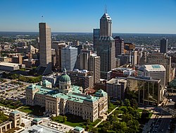
Downtown Indianapolis | |
|---|---|
 Downtown Indianapolis in 2016 | |
| Nickname: "Downtown Indy" | |
 Location of Downtown within Indianapolis–Marion County, Indiana | |
| Coordinates: 39°46′N 86°10′W / 39.77°N 86.16°W | |
| Country | United States |
| State | Indiana |
| County | Marion |
| Township | Center |
| City | Indianapolis |
| Population (2020)[1] | |
• Total | 22,412 |
| Time zone | UTC−5 (EST) |
| • Summer (DST) | UTC−4 (EDT) |
| ZIP code | 46202, 46203, 46204, 46225 |
| Area code | 317 / 463 |
| Website | www |
Downtown Indianapolis is a neighborhood area and the central business district of Indianapolis, Indiana, United States. Downtown is bordered by Interstate 65, Interstate 70, and the White River, and is situated near the geographic center of Marion County. Downtown has grown from the original 1821 town plat—often referred to as the Mile Square—to encompass a broader geographic area of central Indianapolis, containing several smaller historic neighborhoods.
Downtown Indianapolis is the cultural, political, and economic center of the Indianapolis metropolitan area. Downtown Indianapolis anchors the city's burgeoning tourism and hospitality sector, home to nearly 8,000 hotel rooms and several of the city's major sporting and event facilities. Downtown contains numerous historic districts and properties, most of the city's memorials and monuments, performing arts venues, and museums. Since its founding in 1820, the seats of Indianapolis's local administration and Indiana's state government have been located Downtown. Downtown Indianapolis is also home to the highest density of commercial office space and employment in the state of Indiana.
- ^ "Downtown Neighborhood Area" (website). Indy Vitals and The Polis Center at IUPUI. 2016. Retrieved April 8, 2022.
